


Severaldecades ago, my primary flight instructor taught me that being a safe pilot meant stayingon the ground when the weather didn’t look good. When I got my instrument rating a fewyears later, my CFII cautioned me against flying when icing or thunderstorms wereanticipated.
Such advice may be okay for pilots who fly for recreation, but it’s simply unrealisticif you fly for business and use your airplane as a serious transportation tool. This isdoubly true if you fly transcontinental distances, as I do several times a year. It’sseldom possible to fly 2,000 nautical miles without having to traverse at least one majorweather system.
Naturally, there are times when the weather is bad enough that staying on the ground isthe only prudent course. Even the airlines occasionally cancel flights due to weather. Butunless we can operate with a fairly high probability of getting where we need to go whenwe need to be there, the airplane can’t be counted on for serious business travel.
We’ve all heard the clich: there are old pilots and bold pilots, but no old boldpilots. Unfortunately, it’s not that simple. Weather flying requires a certain measure ofboldness. The question is: how much is too much?
Equipment List
Obviously, what sort of weather we take on might be influenced by what kind ofequipment we’re flying. Single or twin? Turbocharged or normally-aspirated? Boots? Hotprops? Stormscope? Weather radar?
 But to be honest, I think equipment isoverrated. For twenty years and thousands of hours, I did serious long-distance weatherflying in a 1968 Cessna Skylane and later a 1972 Bellanca Super Viking — bothsingle-engine, normally-aspirated airplanes with no deicing or weather avoidance gear oreven dual vacuum pumps. The Skylane didn’t even have an autopilot. For the last decade,most of my trips have been flown in my 1979 Cessna T310R — a turbocharged twin approvedfor flight into known icing conditions and with a Stormscope.
Yet I cannot recall a single trip flown in the 310 that would have been cancelled had Ibeen flying the Skylane or Viking. When I think about the scariest weather flying episodesI’ve experienced over the past 30 years, it strikes me that they would have been scarywhether I was flying a Citabria or a Citation. I won’t deny that flying more sophisticatedand capable equipment certainly contributes to my comfort level when tackling difficultweather, and affects some weather-avoidance tactics — such as whether to fly above theweather, below it or around it — but it doesn’t influence my basic go/no-go decision verymuch.
Human Factors
What’s more important to me are human factors considerations. Am I feeling fit andrested, or fatigued? How about my instrument flying proficiency: curent and sharp, orrusty? Do I really have the intestinal fortitude to handle a couple of hours of moderateturbulence without losing my lunch? What is my inner voice saying?
Equally important, if not more so, is whether or not I’m carrying passengers. My wife,for example, is a nervous flyer who is terrified of turbulence and has half the"bladder endurance" that I do. I’ve frequently cancelled or delayed flights whenshe was along that I’d have made without hesitation if I was flying alone. When I’m flyingwith passengers that I don’t know quite as well as my wife, I might have to interview eachone in some depth before deciding whether or not the flight can be made withouttraumatizing them. (When flying in challenging weather, the last thing I want to deal withis a cabin full of white knucklers.)
 The Big Picture
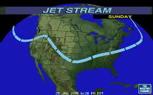
To me, the most important part of briefing for a long flight is getting the bigpicture. Am I flying from good weather to bad, or bad weather to good? (I much prefer thelatter.) What is the overall weather trend: deteriorating, improving, or steady-state?Would the weather would be better if I waited a few hours, or checked into a hotel andleft first thing in the morning?
 I find that it’s hard to get the big picture from astandard FSS or DUATS pilot weather briefing. My usual source of big-picture informationis The Weather Channel. I’ll usually start keeping an eye on TWC for several days prior todeparting on a major trip. A picture is worth 1,000 words. I’ve even been known to chooseone hotel over another based on TWC availability when making reservations for a R.O.N.stopover.
Cable TV "superstations" are also great sources for regional weatherinformation. For example, WGN-Chicago provides exceptional weather graphics for the GreatLakes area, and has TV meteorologists who really know the idiosyncrasies of the region’sweather. Other good regional weather sources on cable TV include KDVR-Denver,KOMO-Seattle, KTLA-Los Angeles, and WWOR-New York, among others.
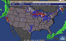
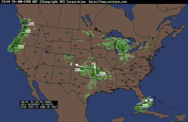 Over the past couple of years, I’ve startedto rely more and more on the Internet for getting the big picture. I carry my notebookcomputer everywhere I go so I can access weather information on the World Wide Web, aswell as obtain briefings and file flight plans using DUATS. The weather graphics on theWeb are absolutely superb, and it’s available on demand…no need to wait as with TV.
Here are a few of my favorite Internet weather sites. You might want to bookmark themin your web browser for future reference. There are tons more on the
URL | Site | Contents |
|---|---|---|
| http://www.intellicast.com | Intellicast | Radar, satellite, surface analysis, etc. |
| http://cirrus.sprl.umich.edu/wxnet | Univ. of Michigan | NEXRAD radar at major US cities |
| http://wxp.eas.purdue.edu | Purdue University | Wide range of weather graphics |
| http://www.weather.com/aviation | The Weather Channel | Aviation weather graphics |
| http://www.usatoday.com/weather/wpilots0.htm | USA Today | Weather for pilots |
| http://www.cnn.com/WEATHER/images.html | CNN | Regional, national, int’l weather maps |
| http://www.rap.ucar.edu/weather/aviation.html | NCAR Aviation Page | IFR/VFR/MVFR conditions, PIREPs, wind/temp/moisture aloft, icing, turbulence, etc. |
| http://www.awc-kc.noaa.gov | NOAA Aviation Weather Center | Numerous aviation weather products including experimental "neural net" icing forecasts |
Preflight Briefing
By the time I obtain my preflight weather briefing, I already have a pretty good ideaof the big picture. As a general rule, I prefer to obtain my pre-flight briefing usingDUATS so that I can review the raw information myself without having it"filtered" by an FSS briefer. I get particularly exasperated at briefers who tryto put their own "spin" on the weather, rather than just giving it to mestraight. (I just want to scream and hang up whenever I hear a briefer tell me "VFRnot recommended" when I call for an IFR briefing!)
An exception to this rule occurs when I’m worried about the weather at the departureairport, because the briefer at the local FSS can sometimes offer worthwhile local weatherknowledge. Telephoning the FSS is also convenient for quick updates during fuel stops whencomputer access is not available. But regardless of whether the briefing is by telephoneor computer, it’s important to keep in mind some of the limitations of the aviationweather forecasts it contains.
About Forecasts
For one thing, forecasts tend to be pessimistic. Weather forecasting is an uncertainbusiness, and the forecasters who prepare aviation weather products have a naturaltendency to make worst-case predictions. Many FSS briefers tend to inject their own doseof pessimism into their briefings. If there’s one thing I’ve learned in three decadesof weather flying, it’s that the weather is almost always better than forecast, seldomworse. I can’t count the number of times I’ve received a gloomy preflight briefing,only to discover that the actual flight was a piece of cake.
Another important limitation of aviation forecasts is that they are based onprobabilities. Just because the forecast says rain or snow is likely over a largemulti-state region doesn’t mean that it’s going to rain or snow at any particular spot inthat region (such as your destination airport). In fact, it’s not at all unusual tofly across such an area without ever encountering adverse weather.
There are certain weather events that are nearly impossible to forecast with anyaccuracy at all. Icing is foremost among these. As far as I’m concerned, standard icingAIRMETs are almost worthless. The only source of trustworthy icing information in apreflight weather briefing comes from PIREPs. One of my great frustrations is that pilotsaren’t more conscientious about filing PIREPs when flying in areas where icing isforecast…especially "negative icing" PIREPs (which is, after all, exactly whatother pilots need to know).
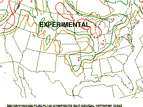 The new experimental "neural net" models forforecasting icing conditions have considerable promise, however — you can check these outon the NOAA Aviation Weather Center web site.
Forecasters do a better job with thunderstorms, but they still have a tough timepredicting exactly where or when the storms will develop, or whether they’ll be readilycircumnavigable or not.
On the California coast (where I’m based), low stratus and fog frequently develops inthe evening and burns off in the morning. I find that forecasters do a pretty good job ofpredicting whether or not fog will form, but they’re often wrong about when it willdevelop (sometimes by several hours one way or the other).
The bottom line is that I’m skeptical about aviation weather forecasts. In the absenceof "hard" information (such as PIREPs and current surface and radar reports),I’m inclined to launch and take a look for myself…provided I’m sure that I have a"solid gold out" in case things look grim.
Finally, it’s important to recognize that the accuracy of aviation weather forecastsdeteriorates rapidly as they project further into the future. A terminal forecast may befairly accurate for the next couple of hours, but the prediction for six hours out shouldbe considered little more than an educated guess. If you’re flying a 4 or 5 hour leg, itdoesn’t make much sense to depend on a preflight briefing for the weather at yourdestination, because that info will be at least 6 hours old by the time you arrive.
Inflight Updates
 Consequently, it’s important to keep closetabs on the weather while you’re enroute. One of the best ways to do that is to monitorboth Center and Flight Watch and listen to both sides of the conversations. It’sespecially useful to hear pilots submitting PIREPs, because you can often tell as muchfrom their tone of voice as from the report itself. You’re also likely to hear a lot ofstuff that never makes it onto the weather wire, like pilots requesting altitude changesor weather deviations.
I also make a habit of keeping an eye on the clock and calling Flight Watch a fewminutes after the top of each hour to get an update on the destination weather. After afew hours of these checkpoints, I have a real good feeling for the trend, and have plentyof time to anticipate problems and formulate alternatives. For example, if I’m headed forhome after dark and worried if I can beat the fog, I’ll keep close tabs on the hourlytemperature/dewpoint spread and get a pretty good idea of when the airport is likely to gobelow minimums.
Flying Ice
The NTSB has ruled that forecast icing conditions are considered to be "knownicing," which means in theory that most light planes are grounded whenever theforecast calls for a chance of ice. Get real! If we stayed on the ground whenever ice wasforecast, we couldn’t fly for 4 or 5 months out of the year in many portions of thecountry. And so far as I can determine, the FAA has never pursued a volation against anairman for flying a non-known-ice airplane in forecast icing conditions except when anaccident occurred.
While I’m not prepared to accept the NTSB’s guidance on ice flying, it is necessary toestablish some basic rules. For example, I have no reservations about descending throughan icing layer at my destination, especially if it’s above freezing at the surface. On theother hand, a departure that requires me to climb through an icing layer gives meconsiderable pause. I have to be darned sure that I can get on-top without picking up muchice before tackling such a departure. This is one of the few situations where a twin has abig advantage over a single, because although twins don’t cruise significantly faster thansingles, they do have a lot more climb capability.
 The scariest ice experience I ever had occurred in the winter of1970 while I was heading home to California from Minneapolis in my Skylane. I wound upgetting stuck in Rapid City, S.D., for several days while I waited out a big snowstorm.Finally, the snow stopped and I headed out to the airport and went to the FSS forin-person briefing. I asked about icing PIREPs, and the briefer told me about a Cessna 150that was practicing holding patterns at 6,000′ and reporting only occasional light rimeice. He also said that a United 737 was due in shortly and might be able to provideinformation on tops and icing.
The United flight landed as advertised, and as soon as the last passenger deplaned, Iran up the airstair, headed for the cockpit, and asked the first officer if he could giveme an in-person PIREP. He replied that the tops were about 12,000 and that he hadn’tnoticed any icing during the descent into Rapid City.
"It’s essential to take immediate action at the first sign of icing. Don’t just sit there in denial… do something!" |
Armed with that information, I returned to the FSS, filed an IFR flight plan westbound,and launched into the soup. Although it was below freezing on the surface that day, Iexperienced no icing during the climb until passing about 7,000′ at which point I startedpicking up a little. By the time I reached 8,000′ I realized my rate of climb had gone tozero and the engine was starting to lose power. The only way I could restore power was touse full carburator heat. It became clear that there was no way I was going to be able toclimb on-top.
I advised Center that I was picking up moderate ice, couldn’t maintain altitude, andneeded to return to Rapid City. The controller gave me a clearance to return and descend.By the time I reached the outer marker, I realized that my windshield was totally icedover and completely opaque. The defroster managed to clear only a dime-sized hole rightabove the hot air outlet. I wound up shooting the ILS and feeling for the runway. Thelanding was a little "firmer" than usual, and the impact caused a large quantityof ice to fall off the airplane.
Upon taxiing in and shutting down, I discovered that there was 3/4-inch of ice on thewing leading edges and wing struts, and that the induction air filter was completely icedover. I pulled a foot-long piece of ice from the wing and plunked on the FSS counter,saying "here’s my pilot report". I then checked back into the motel, at whichpoint my knees went weak when I realized just how close I’d come to getting in serioustrouble.
Could I have made this flight successfully had I been flying a known-ice-equipped Turbo310 instead of a Skylane? Maybe, but maybe not. I’m sure I could have climbed higher than8,000′ in the T310R, but whether I could have made it to on-top is unknowable. If not, thewindshield hot-plate would have come in handy when landing back at Rapid City!
I learned several things from that close call:
No matter how thoroughly you brief, you can never be sure about icing until you fly it.
Trying to climb through an icing layer in a light plane is sometimes impossible.
Most important, it’s essential to take immediate action at the first sign of icing.
(I also learned that a Skylane can haul quite a load of ice without falling out of thesky. I hate to think of what would have happened had I been flying a Mooney!)
The same time-is-of-the-essence attitude is important when ice is encountered enroute. Don’tjust sit there in denial…do something! There are three possible ways to escape froman icing encounter:
Climb (if you think you can get on-top)
Descend (if you think you can get below the freezing level)
Make a 180 and retreat
If you can’t decide whether to climb or descend, try climbing first because youcan always descend later (but necessarily not vice-versa). A turbocharger often makesclimbing the preferred option: if you can’t climb to on-top, you still may be able toclimb into cold enough temperatures that icing is no longer possible. (Icing rarely occursbelow -20C).
As soon as you’ve resolved your immediate icing problem, be sure to file a PIREP sothat other pilots can benefit from your knowledge. It’s even more important to file PIREPswhen you find that there’s no ice despite the forecast. If you think about it, reports ofice-free altitudes are precisely the sort of thing that other pilots need to know about.
Thunderstorms
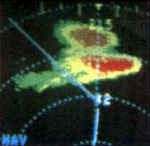 While ice can be penetrated (in limited quantities),thunderstorms cannot. Whether we’re flying a Skyhawk or Citation or Boeing, we have tosteer clear of convective cells. To do this, we must depend on our weather-avoidanceequipment: weather radar, sferics detector (Stormscope or Strikefinder), or Mark IEyeball.
I’ve flown with both radar and sferics. I prefer sferics for enroute weather avoidance(because it sees further and detects turbulence better), and radar for close-in avoidanceduring the departure or arrival phase (because it provides accurate distance information).Having both radar and sferics is even better.
I have a strong preference for avoidance-by-eyeball and use it whenever possible. Agood look at a towering cumulus cloud can tell you a lot more about what’s going on thanany electronic box. If you’re flying a turbo, climbing up to the low Flight Levels canreally help. Although you usually can’t climb above the CB tops, it’s often possible toget a good look at them at FL200 and hopefully circumnavigate them. But eyeball avoidancehas some serious limitations: it’s useless with embedded thunderstorms, and it doesn’twork very well after dark.
 Ifyour airplane is equipped with radar, do yourself a favor and take a good radar course.Weather radar requires considerable interpretation, and most pilots don’t have thetraining required to use it effectively. Both Dave Gwinn and Archie Trammel offer excellent weather radarcourses at numerous locations around the country. Archie Trammel’s course is also available onvideotape.
In the absence of airborne weather radar, it’s tempting to ask ATC for vectors aroundweather. But in my experience, this is risky business because many ATC radar sites aren’tvery good a painting weather, and most controllers have little or no training ininterpreting weather returns. I remember flying into Boston Logan in my Skylane many yearsago. New England was awash with convective activity, and the Boston Center controller wasdoing his level best to vector me around the worst of the weather. But despite thecontroller’s good intentions, he wound up vectoring me right through the middle of acouple of cells. Frankly, it scared the hell out of me.
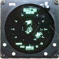
My 310 is equipped with an old WX-10 Stormscope, and over the years I’ve learned totrust it. I’ve never blundered into serious turbulence when following the Stormscope. Whengiven the choice of an airborne Stormscope or ATC radar, I’ll take the Stormscope everytime.
I recall a trip several years ago when I was flying from New Hampshire to Pennsylvania.A line of thunderstorms cut across upstate New York. The Stormscope was lit up like aChristmas tree, but there seemed to be a decent-sized gap in the dots. I advised AlbanyApproach that I needed to make a turn to penetrate the weather where the Stormscope showeda "soft spot". The controller told me that according to his radar, my requestedheading would take me straight into the worst part of the weather.
I decided to trust the Stormscope, despite the controller’s increasingly panickyadmonitions. I soon entered the clouds. Then it started to rain, and the rain gotprogressively heavier. Yet the Stormscope continued to indicate that there were no dotsstright ahead. The controller called me every couple of minutes to make sure I was okay;he was clearly frightened that I would get in trouble and he’d have a lot of extrapaperwork to do. After about 15 minutes of this, the rain stopped and I flew into theclear. I advised the controller that I’d encountered heavy rain but absolutely noturbulence. He was clearly surprised (and relieved).
 This episode serves to underscore the differencebetween radar and sferics. Radar detects water, while sferics detects electricaldischarges. Electrical discharges invariably mean that there are strong updrafts anddowndrafts, but water doesn’t necessarily mean turbulence. Ground-based weather radar isdesigned to measure cloud tops, and airborne weather radar can do the same thing if thepilot knows his stuff (and is handy with the tilt control). But ATC radar offers noinformation on tops, so the controller can tell you about rain but not necessarilyturbulence.
Using a Stormscope effectively requires interpretation, although not as much asairborne weather radar does. I’ve found that one of the keys to Stormscope use is thefrequent use of the "clear" button. Although clusters of dots on the screenusually depict convective activity, the best way to assess storm intensity is to clear thedisplay and see how fast the dots reappear. The faster the dots appear, the stronger thestorm.
Another important lesson is that sferics equipment provides quite accurate directioninformation but only a vague idea of distance. A cluster of dots on the Stormscope displayat the 50-mile range ring might not mean the cell is 50 miles away. If it’s a weak storm,it might be a closer than that; if it’s unusually strong, it might be a good deal furtherway. Often, a single cell will produce electrical discharges of various intensities thatresult in dots on the screen at various ranges; this is known as "radialspread." Although the latest Series II Stormscopes employ software tricks to reduceradial spread, it exists in some measure with all sferics devices.
Summary
The only rule about weather flying is that there are no hard-and-fast rules. That’s whyjudgment and experience are required. Here’s a quick review of some strategies I use:
I consider the human factors affecting me and my passengers before making a go/no-go decision. Even if my aircraft can handle the weather, maybe its occupants can’t.
Before any long trip, I get the big picture by keeping an eye on The Weather Channel or some of the better Internet sites for a few days before I depart.
I get the best preflight briefing possible, of course, but I temper it with the knowledge that aviation forecasts often paint a picture worse than what I’ll actually encounter, but also that some weather hazards like icing cannot be forecast with any real accuracy.
While enroute, I stay tuned in to all available sources of in-flight weather information, including real-time PIREPs and hourly updates from Flight Watch.
I seldom let an icing forecast discourage me from flying (icing PIREPs are another matter!), but I take immediate steps to get out of ice when I encounter it, then file a PIREP for the next guy.
When faced with thunderstorms, I use all available methods to circumnavigate them: weather radar, sferics gear, and especially my eyes. But I’ve learned to be skeptical of weather-avoidance vectors from ATC.
Most important, after obtaining all available weather information, I listen closely to"that little voice" that tells me whether or not it’s okay to go. Call it"gut feeling" or "the voice of experience" if you prefer. Whatever youcall it, so far it hasn’t let me down.
