


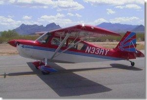
I‘d purchased a 1995 American Champion Super Decathalon, and beforeshipping it home to Japan it seemed almost sacrilegious not to fly it toOshkosh. So I departed Chino, California (CNO) on July 26th at 1300 local,with my camping gear in the back and full tanks. After skirting the Las VegasClass B and deviating around the north side of the Grand Canyon special-useairspace, my first fuel stop was Page, Arizona (PGA, elevation 4,310′). Aftertopping off at Page, I headed for Grand Junction, Colorado (GJT, 4,860’)where I fueled up again and stayed the night.
Crossing the Rockies
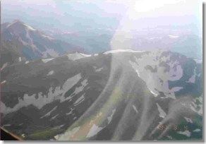
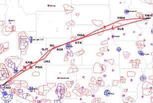 Bright and early on the 27th, I headed for the high passalong route I-70 (elevation 11,990′). But I ran into some serious precipitationand had to zoom down into the valley and land at Eagle County Regional, Colorado(EGE, 6,540′) where I hung out for three hours hoping for a break in therain. I talked to Flight Service and they reckoned it should be okay to theeast towards Denver, so I saddled up and took a look. Sure enough, all therain was on the mountains around Eagle and towards the west, so I skimmedalong under a 14,000 foot ceiling and headed for the pass. I slipped overthe pass, descended to 7,500 MSL to avoid the Denver Class B Airspace, andproceeded on to a little airport in Ogallala, Nebraska (OGA, 3,280′).
While refueling at Ogallala, the man at the FBO told me that some fellowsfrom a Cessna 180 parked on the ramp have been talking to the weather man,and there is a huge line of thunderstorms lined up between Sioux City andOshkosh. These guys were talking about staying the night and then after anothercall to Flight Service decided to head north to Pierre, South Dakota andthen over to Oshkosh in the morning. The radar showed the stuff headingeast-southeast so — not being one for wasting miles in the wrong direction— I decided to head a little north and try to skirt around the stuff whenI find it. This turns out to be a good plan: head on-course until the windscreenstarts getting wet, then divert north until the rain stops. I flew halfwayto Fairmont, Minnesota with on-and-off rain as I repeatedly zigzagged tothe north and then back on course.
By the time I reached Fairmont, Minnesota (FRM, elevation 1,160′), it hadgotten too late to hit Oshkosh, so I tied down the Decathalon and calledfor a nearby motel to come pick me up. I arranged with the local FBO to fuelme up at 0630 so I could try and beat the arrival rush into Mecca.
Oshkosh Arrival
 The 28th dawned clear and with some scattered cloud, and I headed off onthe direct route to the Oshkosh initial approach point at Ripon. While cruisingat 5,500 feet for a couple of hours, I kept reviewing the special Oshkosharrival procedures that I had downloaded from the EAA home page. I had pre-loadedthe lat/lon for Ripon and Fisk into my Garmin GPSMAP-195 so navigating thearrival was a piece of cake. Approaching Ripon, I descended to the prescribed1,800 MSL and 90 knots IAS, and followed the railroad tracks (and GPS) toFisk.
When I got to Fisk, the controller at “Oshkosh Approach” (a trailer in afield at Fisk) asked which runway I wanted (they weren’t very busy), andsince I was planning to camp I requested runway 27. Approaching downwindabeam, Oshkosh tower called me by color and type: “red Decathalon on downwindnorth of the airport, rock your wings.” At this point, the tower normallytells you where they want you to touch down on the runway, short or long,left side or right, on colored spots painted on the runway for that purpose.But when I arrived there were only a couple of airplanes in the pattern,so I had the runway to myself.
On later days, though, the arrival and departure traffic was just amazing.There were frequently four or five airplanes lined up on final for hourson end, and a steady stream of departures from the same runway slotted inbetween the landings. The tower was using three runways simultaneously, andfrequently clearing several aircraft to land at different points on eachrunway. The controllers handling departures stand on the side of the runwaywith flags and handheld radios, and when it is your turn and there is a gapin the arrivals you had better be ready to roll onto your side of the runwayand firewall the throttle because they alternate departures from alternatesides of the runway and there is no time for messing around.
I botched my turn to final when I failed to take the strong crosswind intoaccount, but I slipped to a reasonable touchdown and expedited off the runwayfollowing very explicit instructions from the tower. Once on the ground,flagmen guide you to parking depending on where you want to go, so it helpsa lot if you have a sign in the window of your airplane saying “CAMP” or”SHOW” or “TRANSIENT”. I had my “CAMP” sign displayed so after a bit of taxiingaround on the grass I ended up in row #19 sandwiched between a Christen Husky(who turned out to be from EGE where I had landed in the rain) and a Cessna172 from Vancouver, Canada.
I had covered 1,493 nautical miles and had put 15.4 hours on the tach.
Setting Up Camp
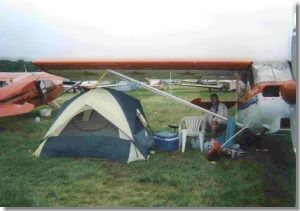 I tied down, pitched my newtent, and inflated my air bed. Then it was off to the building by row #1to register and pay for my camping space ($14/day). It was hard not to beimpressed by how well organized everything was, and this impression grewas time went by.
I had arrived a day and a half before the official start of the EAA Fly-Indeliberately because of the forewarning that the camp area would be fullbefore opening day. Sure enough, the airport filled up quickly as theevery-increasing procession of arrivals continued, including every imaginablekind of general aviation and warbird aircraft.
While walking around and talking to a few fellow campers, I came across someguys camped right next to the runway at about row #3. Their campsite includedevery thing but the kitchen sink. They even had an elaborate “living/diningroom” set up in a mesh-sided stand-up tent. I asked them how they came aboutsuch a prime piece of real estate and they said when they got there onSaturday (4 days before official start date) the parking area wasempty and they could take their pick. I guess it’s like getting decent seatsat a rock concert: the trick is to get there early.
I commented on their mesh lounge, and they replied that the state bird ofWisconsin is the mosquito! They went on to explain that the OSH mosquitoeswere big and plentiful, whereupon I realized that I had no defenses to dealwith these predators. My new acquaintances saw my fear, and kindly advisedthat I walk over to the Wal-Mart at the end of runway 27 and pick up somerepellent spray. I didn’t need any more convincing, and headed there andstocked up on mosquito coils and spray and a few other items which I didn’treally need.
Airplanes and More Airplanes
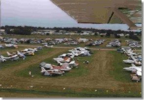 The EAA Fly-In was all itis made out to be. This year the attendance is posted as 840,000 and thenumber of planes at 12,000. They say that 10 percent of all the general aviationaircraft in the U.S. fly in at some point.
During the airshow time between 1500 and 1900 the airport is closed to traffic,and it is also closed at night between 2030 and 0530. The rest of the timeit is just constant airplanes. The sightseeing helicopters fly a fixed routeas does the Ford Trimotor and the Fuji blimp. The airplane noise is constant,with continual takeoffs and landings by everything from the WW2 bombers,and fighters to the J3 cubs and ultralights. Nearly every morning, I wasawakened by the roar of P51s as they went for an early morning sortie. Theday before show opening (the 29th) I counted twenty-one P51s lined up. Igave up trying to count the T6s and T28s. There was just so much to see thatI never even made it to the Ultralight area. The fly-by of the B2 and theSR71 was a sight. A U2 spyplane was also on display, looking just like ahuge motorglider.
The acrobatic flights were something else. For me, the pick of this year’scrop was Sean Tucker in his Pitts — one crazy bloke for sure. The finaleof his airshow performance is to cut three ribbons on the same pass, thefirst with the tail while inverted, the second with a wing in one knife-edgeposition, and the third with the other wing in the other knife-edge! My otherairshow favorite was the Gee Bee replica. I had read all about the pilotand his plane and aerobatic routine, but to see the plane up close on theground and then flying the routine was quite something.
Where’s Are Those Guys?
A bunch of friends were due to arrive from Chino in a Beech Queen Air onthe 30th with a valuable bit of “cargo” of mine. They didn’t make it by the2030 cut off time, and I started getting worried. The history of this planeis that it was an aerial survey workhorse in Japan — it even has bubbleside windows in the cockpit and a sliding hatch in the belly for cameras— and my Japanese instructor friend bought it for $10,000 because the engineswere run out and the Japanese don’t allow flying past TBO. He then put somevery large ferry tanks in it and flew it across the Pacific via the Islandsto Chino, California. That was three years ago. Two trips to Oshkosh andit still flies on the original engines which are a little past TBO now. Itdoes use a fair amount of oil though!
Anyway, a quick phone call to California confirmed that the Queen Air wason the ground in Nebraska, delayed due to some of the same sort of weatherI had seen in the Colorado mountains. Their departure had been delayed whena coin slipped off the glareshield when they were taxing out and fell intothe empty cigarette lighter socket unobserved, and with dire consequencesfor the electrical system. Finding the reason for the electrical failure,getting the coin out of the socket, and locating the poppedcircuit breakerwas apparently not as easy as one might have thought, even for a veteranof a transpacific flight.
ATIS…What ATIS?
Next morning the arrival ATIS was saying the camping areas were full andthey were not accepting arrivals from twins. What the ATIS didn’t know wasthat there had been a lot of departures and there was in fact a lot of vacantreal estate in the aircraft camping area. I hoped my friends in the QueenAir would be as smart as the guys I talked to that rolled in a light twinand got a parking space. When I asked them if the ATIS was saying that alltwin parking was full, they just mumbled something about how the ATIS didn’tseem to be working when they arrived. So apparently the trick is not to payattention to the ATIS — just land and look for a space.
About midday I was starting to give up on my friends in the Queen Air andwas having a nap in my tent with the handheld on tower frequency when thephrase “…Air, rock your wings” woke me up. Sure enough, it was my friendsand they had ignored the ATIS, so I headed for the runway and eventuallyguided them into a vacant twin slot just a couple of rows down from me thatI had been watching all morning.
They stepped down with a chilly bin (that’s Kiwi for “cooler”) of beer, andthere was a lot of “where the hell have you been” and excuses like “we wereflying along at 10,500 feet and didn’t realize we had got here until theVOR flipped from TO to FROM, and then we had to make a 180 and go back toRipon, etc., etc.” Apparently, no one had thought to bring a GPS becauseeach thought someone else would bring one, and the Queen Air’s DME doesn’twork and only one VOR works, etc., etc. — more confirmation of my earlyfears about the safe arrival of my “cargo”. Thank goodness the “cargo” wasgoing back in the Decathlon. Even though I only have one engine, at leastI have two GPSs and a VOR!
Shopper’s Paradise
It would seem that all the manufacturers of all the equipment made for GAaircraft and homebuilders come to the show to peddle their wares. All thediscount houses (like Aircraft Spruce) have booths set up making sales atspecial Oshkosh prices. I shopped around for a headset for the “cargo” andfound price variations of 15+ percent for the same item. Another thing Ipicked up at a 20% show discount was a two-person Aerox oxygen system withoxygen-conserving cannulas. I decided for the trip back over the ColoradoRockies, I would go in style at 14,000 feet (level with the peaks) insteadof staying legal at 12,500 without supplemental oxygen in the passes andvalleys.
You can buy anything from an AN3 bolt to a business jet at Oshkosh. All thecertified plane builders are there as are all the kit manufacturers. If youjust want to look at planes they are all there: antiques, classics, amphibians,warbirds, ultralights, military iron from F16s to C17s, certificated “spamcans” of every description, mass quantities of LongEzes, Lancairs, Glasairs,and RVs, and every kitplane ever built.
I was at the G202 acro plane tent talking to one of the salespersons andwas just starting to ask if he happened to know a fellow Kiwi who was supposedto be getting one of the neat little numbers, when who should walk up butDoug Brooker himself! It took a while to convince Doug that it was reallyme and it is really a small world. He spotted Kazuyo and came out with hisstandard “anata wa utsukushi desu” (you are very beautiful) which I’m surethat is the only Japanese phrase he ever learned from his trips to the orient.Still, it was great to see someone I knew from New Zealand.
Time to Go Home
After six days of hiking all over Wittman Field, I still hadn’t seen everything.But the Fly-In was over and it was time to tear down the tent, join the departurequeue, and “head for the hills” — literally.
I loaded all my excess gear into the Queen Air in exchange for you-know-whoand headed to the weather briefing tent. The night before, we had had a decentthunderstorm and plenty of rain just to keep things interesting and messup the going-home party. The radar and satellites showed more out therestrategically placed between where we were and where we wanted to go. Justto make things interesting there was a front there, too. The people goingin our direction were debating on going north or south to avoid it, but Ifigured I would go back to my proven strategy of heading straight down therhumbline and going around whatever I found (or make a 180 and come backif I couldn’t).
Good plan again! I went straight through a “gap in the crap” and escapedto the sunny side with just a few 20-degree avoidance maneuvers, and justenough light rain to wash the windows.
We flew over mile after mile of flat green American countryside interspersedwith rivers, lakes and interstate highways, and subdivided by the very neatlyarranged grid of north-south and east-west roads (you would have to be prettydumb to get disorientated out here). Three hours and three hundred mileslater and it was time for a pit stop and I chose a little airport calledStorm Lake, Iowa (SLB, 1,490′) because it was right on my track and the GPSdatabase said it had avgas.
Earlier, I had planned on a little airport called Pocahontas (also righton-track) because the name was reminiscent of my childhood cowboy-and-indiancomics and movies, but it turned out to be 30 miles too soon. A lot of thenames in this area such as Sioux City, Sioux Falls, etc., had me thinkingof the history of the area, how hard it must have been to travel all thatway by horse and covered wagon, how rail travel must have changed everything,followed by automobiles and then air travel. As you move further west andget to the mountains, then the deserts and canyonlands, and finally California,the whole expanse and variety of the landscape is awe-inspiring, especiallyfor a bloke like me from a small island nation.
FBO Repartee
Another good reason to land at Storm Lake was that the windscreen was gettingopaque from the encrustation of splattered of bugs. It was as if someonehad loaded a shotgun full of insects and fired it at the plane from aboutten feet. So Storm Lake it was. Final approach was over endless expansesof green Iowa cornfields. We touched town and taxied up to the fuel pump.”Fill er up please, mate,” I said to the fellow from the FBO, which elicitedthe usual “Long way from Australia aren’t you?” which led to the usual “No,New Zealand,” which led to the usual “Yep always wanted to visit Noo Zealand,they say it’s real nice down there,” which evoked the usual “And where isthe men’s room?” I still have a lot of trouble figuring out why every AmericanI meet wants to go to New Zealand when they have it all and a lot more intheir own country — it must be the people.
After the men’s room, we realize hunger is setting in and the next stop willbe another three hours. I ask if there is food nearby and the man says acouple of miles down the road which certainly is discouraging as the temperatureis around 38C (100F). “Any taxis?” No. “Any chance of a lift?” Sure. An oldbloke appears out of the back and says “come on” so we jump into his oldbomb and off we go. On the way I ask him why the place is called Storm Lakeand he says the lake is shallow and the winter northerly kicks up some bigwaves not to mention the snow that hits the town from across the lake. Hardto imagine in the sweltering heat with the air conditioner going full tilttrying to catch up. We grab some food and head back to the airport. The blokewon’t take any money for the trip.
While we are eating our lunch in the airconditioned FBO office I notice sometee-shirts in a glass case with a picture of an ag biplane with “Barts FlyingService, Storm Lake, Iowa.” I decide this has got to be a fairly unique tee-shirt— not too many floating around and the perfect conversation piece for thebar at Waitemata. It turns out Bart is the old bloke that ran us into townand has three ag planes and does pretty much all the spraying in the area.I mentioned Pocahontas and he tells me there is no gas or FBO there any longer— just goes to prove you can’t believe everything the GPS tells you. Barttells me his middle son is away at Oshkosh — wanted to borrow a plane butBart says he didn’t like the idea of his plane getting bent by a thunderstormso he made him drive over — hmm, food for thought.
Westward Ho
It’s time to get back in the saddle and head west again. Next stop was tobe the closest airport with avgas on the rhumbline at about 350 miles orso. Many miles of green fields later, the ground starts to rise and get abit browner, and the appropriate place turns out to be Sterling, Colorado(STK, 4,040′) and the gas turns out to be the cheapest of the trip so far:$1.75 per gallon.
(The most expensive was $2.20 but there, this guy rushed up to the side ofthe plane and threw down a piece of red carpet. Only trouble was he was onthe wrong side of the plane and when I opened the door and started to getout on the other side he picked up the carpet and rushed around to the doorside. He was obviously embarrased so I just said “fill er up, mate” whichlead to “long way from Australia, eh” which lead to…)
 After Sterling, we have to skirt around and underthe Denver Class B at 7,500 feet and then make the big climb to 14,000 whileturning on the new O2 system. This works for the first few miles of mountainswhile we aim for Grand Junction. Further into the hills and we have to startcoming down bit by bit to stay out of the clouds and a little further weare back to valley soaring in the rain. We manage to get past Eagle whereI’d parked in the rain on the way eastbound, and we push on another fortymiles before calling it quits at Garfield County Regional Airport in Rifle,Colorado (RIL, 5,540′).
The rain had washed all the bugs off the windscreen, and the bloke I hadbeen talking to on UNICOM off and on for the last 20 miles (to make surethe viz was still okay) drove out in the now light rain (funny how it easesoff as you land) started describing how to get to the town and motel. I repliedthat it looked a bit far, and he said “no, you go in this van I have broughtout for you, and what time do you want your airplane fueled in the morning?”Now this was fairly typical of everything outside of the cities. Here weare, no intros, no nothing and he tells me to take his wagon for the night.Sure, the Decathlon is worth a heap more than his van, but even so.
The girl at the motel in Rifle told us where the best food in town was, sowe headed straight there in our borrowed wagon and ate too much. This musthave been a knee-jerk reaction, since we had been on a diet of freeze-driedcup noodles and beer at Oshkosh.
More Weather Problems
The morning in the mountains turned out to be not much better than last night,but our friendly FBO man reckoned we should be able to at least get downInterstate 70 to Grand Junction. The weather service was pretty pessimisticand there was supposed to be a lot of junk moving northeast right in thearea we want to traverse. We flew right over the top of Grand Junction, butsure enough ran into a wall of water twenty miles beyond. Okay, Plan B wasto skirt to the south because the stuff is supposed to be going northeast.This seems to work for awhile, but eventually we found ourselves headingsouth up a valley with Option C looming rapidly (land or go back).
Knowing there was an airport ten miles up the highway we were following madethe “land” option an obvious choice. Having been tuned to UNICOM for thisairport for a while, I picked up another plane landing and asked him whatis in store. He said there was rain at the field but the visibility was okay,so I told him we would be there in a few minutes. We landed at Monticello,Utah (U43, 7,000′) in worsening rain. The UNICOM operator came out and toldme he had already spoken to Flight Service, that the weather was expectedto be lousy all day, and that he had a pick up from a nearby motel comingand do we want a lift in?
It sounded pretty convincing that we would have to hang out here maybe tilltomorrow, so we hitched a ride with him and his wife and kid in the motelvan. It turned out he was headed northwest as opposed to our southwest route,and the likelihood of bad weather in his direction was much greater thanin ours. I immediately regretted my hasty decision because it was still only10 am, but checked into the same motel anyway. I sat down on the bed andlooked at the charts, and decided that my latest decision time was 1400 tobe in the air and on the way by 1500 to get into the L.A. area at a reasonablehour.
Rain came and went for the next couple of hours, but by 1330 the sky in ourdirection of flight was looking much better. I called FSS and the weathermanlooked at his radar and confirmed my suspicions. The goo had moved off, butwhen I suggested going south to avoid anything that might be still aroundhe said no — there is now a line of thunderstorms to the south over theGrand Canyon so don’t go south — go west first until close to Las Vegasand then head for L.A. That was enough for me so it was down to the frontdesk, check out and get a lift back to the airport. The motel said they wouldpick us up again and give the room back if we had to come back.
Montecello was the highest field I had departed from so far, and the temperaturehad the density altitude at over 8,000 feet. I leaned the engine and stoodon the brakes right at the start of the runway for a short field take offbut we still only used half of the strip getting off.
We climbed out to 10,500 around the big hill in the way and out over thecanyons and red rock mesas of southern Utah towards Kanab, which was to bethe next stop for gas. There were nothing but nice fluffy white clouds aroundto weave around, and nothing but smooth picturesque flying for aboutan hour. Not many places to land in an emergency but I guess you have togrin and trust in your luck sometimes. Soon we were crossing the ColoradoRiver north of where it is dammed to form Lake Powell before it goes throughthe Grand Canyon and comes out at the other end south of Las Vegas. Herethe Hoover dam keeps the water back to form another big manmade lake, LakeMead.
After the upper reaches of Lake Powell, we started to see the northern edgesof the stuff the weatherman was seeing earlier on his radar. We encountereda bit of light rain here and there with lower clouds to cruise under andcumulonimbus distant south. About twenty miles out of Kanab, Utah (KNB, 4,860′)just before the Arizona border, I made contact with UNICOM and was told thewind was favoring runway 01. Ten miles out, and now they were saying runway19 was in use and there was a rain squall moving in. Here we go again! Ilined up on final with the far end of the runway all wet and shiny and myend still relatively dry. A bit of a gust together with heavy rain messedup my planned grease-job landing, and I taxi to the gas pump and shut down.I radioed the man not to bother to come out until the squall eases off, andwe sat for ten minutes with the rain pelting down. Kanab is in the desert,by the way.
Home Stretch
After a while we got filled up and the fueler told me that it had been likethis off and on most of the day. The south and east still looked black, soI elect to hightail it out of there to the west and south before the nextrainstorm arrived. The wind was back to favoring runway 01 now, so we madea climbing left turn and headed straight for Las Vegas weaving around a coupleof fairly large soon-to-be-thundercloud formations.
There is a corridor of tourist plane traffic heading back and forth betweenLas Vegas and the Grand Canyon, and the chart warns you to announce yourselfon a special frequency. I dutifully listened in as we approached the areabut could make no sense of the abbreviated calls these local Grand Canyontour operators are making. They were all calling in at “55” and “65”. I madethe assumption that this must altitude, and since I am cruising at 10,500feet I figure they would be no factor. I looked around down below and sureenough there are twins trekking back and forth a few thousand feet below.I looked up again and suddenly a 727 (supposedly full of gamblers) went whistlingby on approach to Las Vegas. It looked closer than it was, but just seeinga jet from my little cockpit always gives me a fright anyway.
Soon we are flying along over Interstate 15 that goes from Las Vegas to LosAngeles, and also the main trunk railway that goes all the way over thosesame mountains we have just crossed. You can see the trains and they seemto be a mile or two long.
The GPS was now saying one hour to go and suddenly my cargo came to life— having been quietly reading a book, sleeping or quietly gazing at halfof the USA for the last 14 hours in the air. “How long to go?” was the question.”58 minutes and 40 seconds or thereabouts” was my reply. “Any airports aroundhere?” “Well yeah, but why?” The last thing I wanted to do now was land fora pee stop, so I agreed to expedite the arrival. Previously, Plan A was toskirt around the various bits of nuisance airspace between us and Chino,but since a direct route is now of pressing concern I called SoCal Approachat 10,500 feet over the hills northeast of the Los Angeles basin. They gaveme a squawk and clearance for a rapid descent straight to Chino. Four frequencychanges and one “turn to a heading of 180” and then “resume own navigation”later, we were on a two-mile final for runway 26R at Chino. A final three-pointlanding finished off the 3,000 nautical mile adventure to Mecca and back.Tower greeded me with “Decathlon 3 Romeo Yankee, taxi to parking, monitorground point 6.” I replied “thanks mate, 3RomeoYankee,” and taxied post hastefor the nearest loo.
The next week was spent dismantling the Decathalon and packing it in a container,and she is now headed for Japan. Now I wonder what it would be like to flyit down to New Zealand … .
