


I cut my teeth as a pilot in the Midwest — the Chicago area to be exact — and I learned lots about weather during those days. Among the things I learned is that 97 percent of weather is safely navigable (by a qualified and current pilot in a properly-equipped airplane, but that’s another subject for another article), and the important part is staying away from the other 3 percent because it’s definitely going to turn you into a statistic. The obvious safe way to approach this subject is to never fly when there is a chance of unpleasantness in the forecast, but as those of you in the Chicago area know, had I done that I’d probably still have about 300 hours.
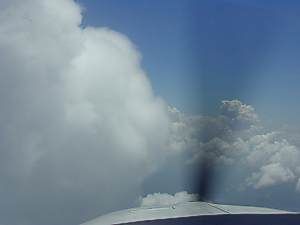
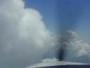 From March through October there were usually thunderstorms somewhere in the Midwest and although most of those tended to be of the isolated-to-scattered air mass type, they can still pack a punch. I’ve seen the isolated magnificent specimen climb 60,000 feet into the sky and just dare any puny airplane to come visit. One of the best things about thunderstorms, though, is that they don’t sneak up on you like other nastiness such as airframe icing and fog can do. It’s pretty hard to be stealthy when you’re 10 miles tall and putting on a light show that can be seen for miles!
Where Do Microbursts Hang Out?
We’ve all been taught not to fly into cumulonimbus clouds and I can’t imagine any pilot among us who would do that — at least not willingly! True, some are suckered in by embedded thunderstorms, but that’s not common since most try to remain VFR around the larger TRWs so we can see what we’re flying into. You can encounter plenty of unpleasantness outside of the main cloud of a thunderstorm, however, and one of the most sinister of these is the downburst or microburst. Some refer to this as wind shear and, when I taught at FlightSafety, we used to refer to it as wind shear training, but wind shear is a bit too general and a bit too benign a term for the airplane-slapped-out-of-the-sky chain of events unleashed in a microburst.
What Are Microbursts, Anyway?
So, what is a microburst, anyhow, and what causes it?
 Basically, microbursts are just parcels of cold air rocketing down out of a thunderstorm. The late Dr. Theodore Fujita of the University of Chicago defined microbursts as downbursts from a thunderstorm that are 2.2 nm (4 km) across or smaller and are from five to seven minutes in duration. Dr. Fujita studied the 1975 Eastern Airlines (EAL) Flight 66 crash at JFK and determined that it was a microburst that had downed that flight. The EAL 66 accident and an Allegheny crash at Philadelphia in 1976 were the beginning of the recognition by the aviation community that thunderstorms might pack a far more powerful punch than was previously appreciated.
The FAA responded to this threat by developing the Low Level Wind Shear Alert System (LLWAS) in the late 1970s. LLWAS consists of a network of anemometers (wind sensors), which are strategically located on and around the vicinity of an airport to measure the speed and direction of wind. The data collected by the anemometers is transmitted to a master station (typically located in the control tower) which detects wind shear or microburst conditions. Once the system detects a wind shear or microburst, warnings are presented to controllers who in turn relay the messages to pilots approaching or departing the airport.
The Holes In The Net Are Too Big…
The LLWAS is still in use today, but microburst encounter events have shown that, although we built a net to catch these little devils, we made the holes too big! On a July day in 1988, there were several thunderstorms in the area of the Denver Stapleton Airport. This is not an uncommon event in the summer in Denver. Also, there were several United Airlines flights in the area. This also is a rather common event in Denver. The airport was equipped with a LLWAS. Also, the FAA was testing the new Doppler radar at an Air Force base southeast of the airport.
Several flights operating in the area that day reported some pretty scary microburst-related events. One pilot reported that he had initiated a go-around and had takeoff power established for 55 seconds before the aircraft began to climb. (That HAD to be the longest 55 seconds of his life.) Another pilot reported a 65-knot airspeed change. Now during the whole time these incidents were going on, the LLWAS reported a maximum of 15-knot gusts. The sensor towers were far enough apart that the microbursts snuck in and were not detected. The Doppler radar being tested, however, recorded the 65-knot speed difference across the core of one microburst. Clearly, LLWAS is not a panacea and, while it does work in the area immediately near and on the airport, the system does little for planes and crews on approach or maneuvering in the terminal area.
…But, What Causes A Microburst?
 The short answer is: thunderstorms. You’re already aware that there are severe up- and downdrafts associated with cumulonimbus clouds. It’s this air movement that allows hail to form. The warmer water droplets from below are swept above the freezing level by the updrafts. As the water freezes, it begins to fall again until caught in another strong updraft. The size of hailstones reaching the ground is a pretty direct indicator of the strength of the thunderstorm. It takes some pretty strong updrafts to lift pieces of ice the size of tennis balls back into the upper levels to let them accumulate another layer of ice.
Once the thunderstorm reaches the mature stage and the rain begins to fall, the stage is set for a microburst. As the rain falls it is usually accompanied by a downdraft. As this rain-laden air begins to fall, the rain begins to evaporate. This evaporation cools the air further. The colder and denser air now accelerates towards the ground. Upon ground contact, the air spreads out in all directions. Characteristic patterns can sometimes be found in vegetation struck by a microburst — the plants will be flattened out away from the center of the ground strike as though a bomb had burst in the center.
So, What Makes These Things So Dangerous?
What makes microbursts so dangerous? Many things, not the least of which is that they have the potential to swat airplanes out of the sky. Piston-powered airplanes seem to have a slight advantage since they do not experience a power-lag or spin-up time on the engines as do turbine-powered machines, but they usually also have less power and less inertia to start with than does turbine equipment.
|
One of the sneaky things about microbursts is that if you’re a little short on situational awareness, the apparent performance increase that can be the first sign of a microburst in progress is sometimes ignored and the flight presses on to further danger.
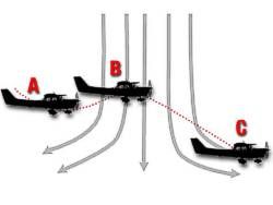
Take a look at the graphic to the right. This is the classic microburst diagram we’ve all seen. Notice the airplane at position A. It’s just beginning to feel the effects of the outflow from the microburst. This sudden increase in headwind will cause an apparent increase in performance. The airspeed will increase, the rate of descent will decrease and the almost overwhelming urge of a pilot at this point is to pull the throttles back and push the nose over. Bad mistake. This is the time to get out of Dodge. Microbursts are like everything else associated with thunderstorms — there’s no way to judge how bad they are from looking at them and by the time you find out just how bad it is, it’s too late. The proper action at this point is to push up the power and abandon the approach.
If you press on, you will find yourself at position B in the graphic. You will fly out of the headwind and into the tailwind. The suddenly decreasing headwind and increasing tailwind will cause degradation in performance equal in magnitude to the increase experienced at point A. You can see that if the headwind portion of the microburst caused a 30-knot jump in airspeed you’re now going to lose 30 knots. If you pulled the throttles back in response to the headwind increase, you’ll be in real trouble now. This is quickly becoming an unrecoverable situation.
When all the talk about wind shear started in the late 70s, I had a real problem understanding how this happens. After all, we’ve all had it drilled into our heads since that first hour of dual that airplanes only "feel" wind on the ground and that once you’re airborne the airplane moves in concert with the air mass it’s in. We’ve been taught to apply windspeed to airspeed to arrive at a groundspeed figure. The thought that wind could have an effect on airspeed was a hard one to swallow — and still is for many.
Oh, No, Not A Physics Lesson…
The physics of wind shear can a bit daunting, but if you just get it into your mind that in this instance the response of your airspeed and groundspeed is going to be the reverse of what you would normally expect, I think you’ll see why these localized phenomena are so dangerous.
 If you fly into a microburst the first indication, as we discussed above, can be an apparent increase in performance. To put it simply, the airplane tries to maintain its same speed across the ground. Inertia keeps it from adjusting quickly so the increasing headwind calls for an increase in airspeed to maintain the ground speed. So far this doesn’t sound too dangerous, and it isn’t — unless you press on. Then things get pretty scary pretty quickly.
If you fly through the headwind portion of the microburst you come to the point (position C in the graphic) where the headwind decreases and quickly becomes a tailwind. Now your airplane, not knowing this is a wind shear, just tries to keep its speed across the ground from changing. If you have responded to the headwind portion of the shear by reducing power and pushing the nose down to maintain the glide path, you’re really going to be in hot water now. Your airplane indicating 80 knots is going to try to maintain the 50 knots across the ground you had been maintaining. Since the airplane cannot change the wind, it will change speed — you will suddenly find yourself if a machine now indicating 50 knots and sinking out of the sky.
Full power may or may not save you at this point, but it probably would have if applied at the first indication of the microburst activity.
…Escape Maneuvers…
Once you are in the grips of a microburst, the maneuvers required for escape may seem extreme, but they are your only hope. Apply full throttle IMMEDIATELY and pitch up to a climb attitude — or an attitude that will arrest your rate of descent. You may have to fly on the edge of a stall — in a jet, you should pitch up to the point of stick-shaker activation — to escape. It’s best to think of this maneuver as an escape maneuver so you don’t confuse it with a normal go-around or missed approach. This is a far different and more critical maneuver and you are trying to escape danger, not simply abandon an approach. This is not the time to be "smooth and gradual" in your application of power — firewall it! If you escape the microburst you can worry about your engine later!
…The Key Is Avoidance
The key to successfully dealing with microbursts is awareness and avoidance. Be aware of the weather conditions that can cause these powerful phenomena and avoid them at all costs. Remember, an escape maneuver may or may not work. Luckily, thunderstorms are not too stealthy and there are usually ample warnings that they are in the area.
Some Tips
 Here are some DOs and DON’Ts that may help you deal with this weather:
DO get a thorough weather briefing including the possibility of convective activity.
DO watch the temperature/dew point spread. Microburst activity is more common and more severe with large temperature/dew point spreads. (The falling rain has more opportunity to evaporate and cool the descending air.)
DO maintain visual conditions any time thunderstorms are in the area.
DO perform an escape maneuver any time you think you may be dealing with a microburst.
DON’T fly under ANY thunderstorm any time for any reason!
DON’T fly under the overhang of any thunderstorm.
DON’T fly into or near a rain shaft.
DON’T fly under virga — that’s a built-in microburst.
DON’T depend on the fact that the flight that landed before you didn’t report any problems. Remember, microbursts have a short life span and it may not have been there when he passed by. Also, they’re relatively small — his flight path may have been offset enough to miss it. Also, he may just be too scared to talk!
Thunderstorms put out some of the most dangerous flying weather that can be found, but luckily we are able to see and avoid them also!
