Mother Nature is infinitely complex as is the weather that comes with it. After 40 years of flying and some good meteorology training (courtesy of the Swedish Air Force) I’m still occasionally baffled on how things play out. Here are a few examples where the unsuspecting pilot can get surprised.
Temperature Changes
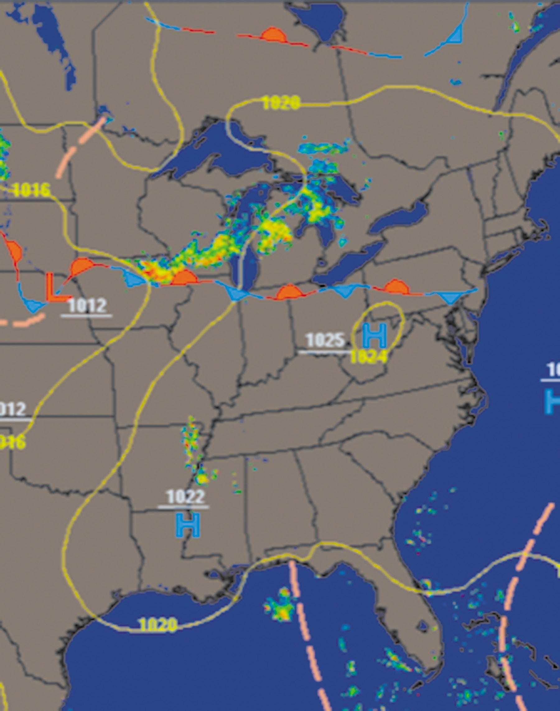
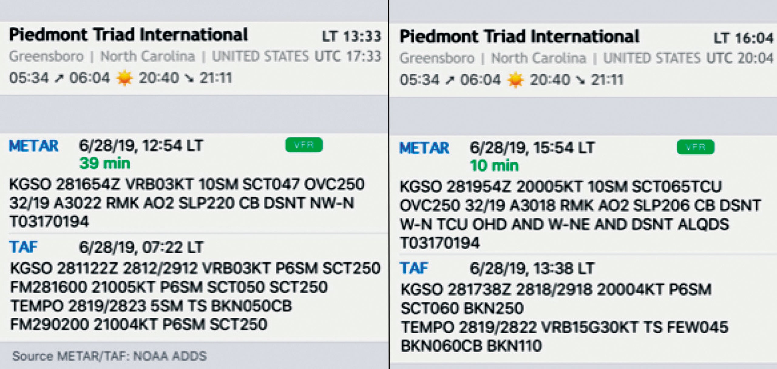
You’re planning a summer trip to Greensboro, North Carolina (GSO). A glance at the Surface Analysis (SA) shows a large high-pressure area; radar shows nothing near and the METAR and TAF are excellent. What could possibly go wrong?
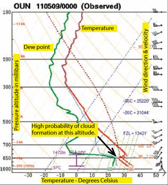
The forecasters have a plethora of information available that the average pilot couldn’t make sense of. This includes vertical soundings of the atmosphere, i.e. a graph that describes (among other data) the temperature, humidity and wind at different altitudes. This is used to determine the stability of the atmosphere and forms the basis of the probability of thunderstorms. And therein lies the rub—probability.
Underlying data, no matter how good, can never accommodate the complexity of nature. If the temperature at one locale rises more than forecast, a typical summer thunderstorm my occur. Or, if the temperature aloft drops by some amount because cooler air blows in—same result. When the next TAF comes out six hours later there is a TS listed with variable winds gusting 30 knots. Not quite what you had expected.
Contrary Winds
Basic weather school teaches that wind flows parallel to the isobars and that would be true all the way to the ground if there was no friction towards the underlying terrain. Well, there is, and the retarding effect in this so-called friction layer slows the wind and backs the wind direction toward the left. The amount depends on the underlying surface. Over the oceans and airports nearby there will be little friction, consequently the winds will be stronger.
Obviously, this will be considered by the professionals making the forecast. However, what is true for the surface may not be true a few thousand feet up.
I’ve had circumstances when the winds reported by the tower were well within the aircraft limitations. But descending on final—looking at the runway through the side window, while approaching at 150 knots—combined with the amount of denture-dislodging turbulence made it obvious that a landing attempt would be inappropriate.
Assume one runway 0927 with surface winds 180 degrees at 20 knots gusting to 30.
Although 180 degrees is the average direction, the wind may vary between 150-210 degrees.
The strong gusts (30) will then be from 210 degrees and the weaker from 150. Consequently, you’ll want to land on runway 27 for the shortest and safest landing. Even at a towered airport don’t hesitate to request a different runway. They will often approve this for one obvious reason: you may be the only one out there trying to land in these conditions.
Mountainous Terrain
The same thing will happen at mountainous aerodromes, but for somewhat different reasons. The varying topography will cause disordered wind patterns like a stream flowing over rocks—random and chaotic turbulence that is unpredictable.
The locals may be familiar with the peculiarities of their favorite landing spot (and to some extent the meteorologist making the forecast). But this is beyond the scope of most traveling IFR pilots. With any significant wind strength (or cumuliform activity), be cautious. Plan an alternate in more open terrain.
Fog
Next to icing and thunderstorms, fog is a major nemesis to the alert aviator. We all know the major types of fog from ground school—advection, radiation or orographic fog—but there is one that’s rarely discussed.
The formation of fog is (in theory) a simple and well understood process. However, we cannot know the exact characteristics (namely temperature and humidity) at but a few selected points. Even airports where visibility issues are at the forefront, generally it’s only measured in one specific location and height.
The amount of moisture a parcel of air can absorb increases with temperature. One of the quirks of nature is that this is not a linear relationship. You can have two air masses with slightly different temperatures, each not quite humid enough to condensate until they (for whatever reason) are forced to mix and condensation (fog) starts.
This is quite a common spectacle over water and literally looks like smoke coming off the surface. For coastal airports this can be an issue, but is a well-known phenomenon and will likely be in the forecast.
It can happen anywhere and quite suddenly. I’ve seen instances (typically in fall and spring) where the sun rises in a clear sky with calm winds over the airstrip, promising a perfect flying day. Suddenly, even after you think any risk of radiation fog would be well past, heavy fog ensues.
Presumably, the slight heating from the rising sun has been enough to stir the stable air and cause mixing of two layers of air of slightly different temperature, but close to condensation.
The moral here is clear: Always expect a surprise on an early morning flight, especially so if the winds at the airport are calm or light.
Refracted Sunlight
Another “morning issue” can happen even if good conditions are reported. If the ATIS is calling for a mile or more of visibility with bases above minimums you wouldn’t normally expected any issues.
This may not be true if you’re landing toward the east and a rising sun. Reported visibility is an estimate made by equipment (or occasionally a human observer) on the ground. Flight visibility is a different animal.
Descending into the rising sun can be annoyingly bright, and while you may have a clear view of ground under you, forward visibility may be minimal. The result is occasionally a missed approach.
The remedy is often easy—land in a different direction. Since these conditions usually only occur when there is little wind, this should not be an issue.
Interpreting Radar
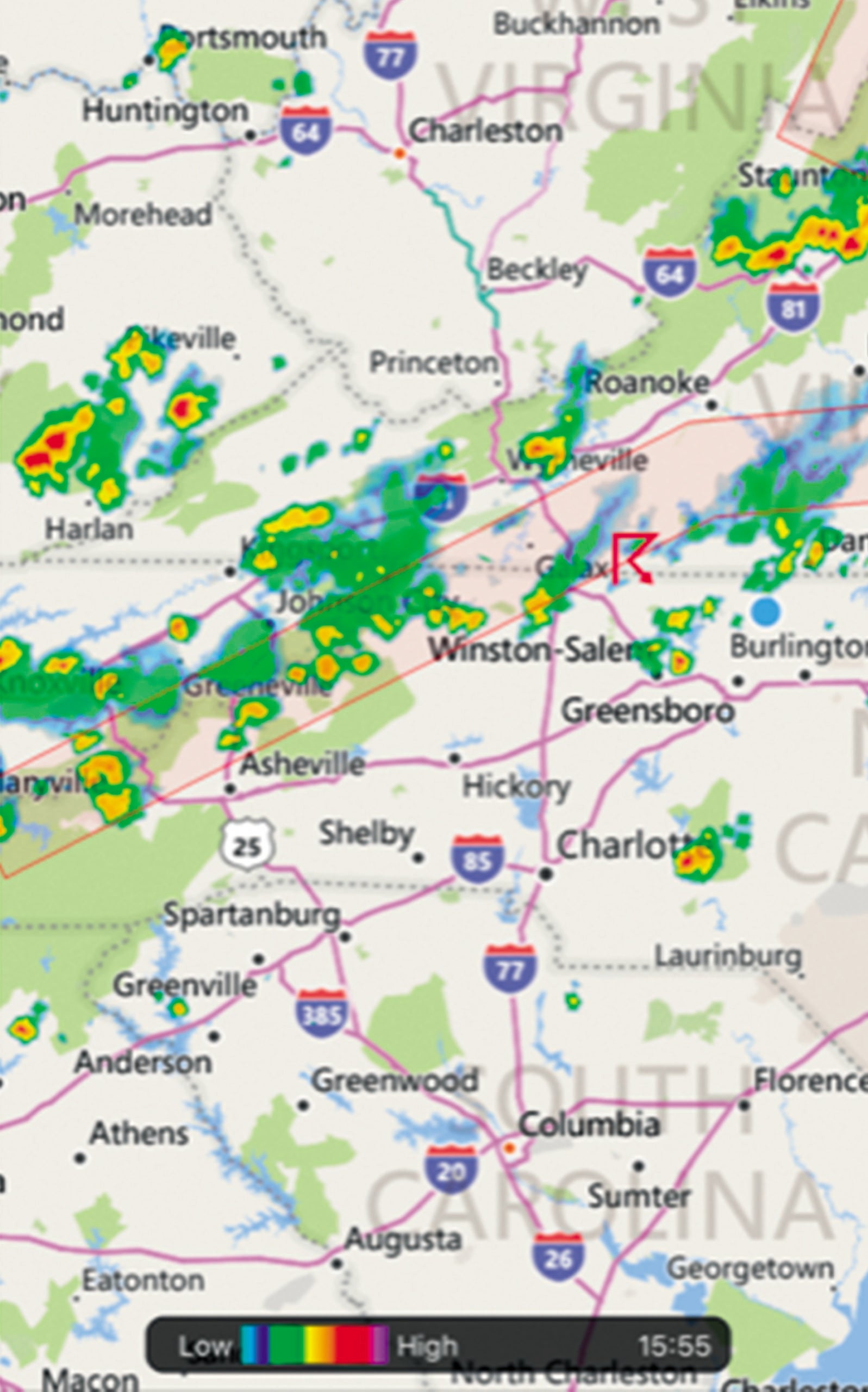
While cruising along you may occasionally hear ATC report “Moderate to severe precipitation x miles away and y miles in diameter.” ATC will issue this alert when adverse conditions appear on their radar screens. While it’s an event of which you should take note, it occasionally turns out to be crying wolf.
Airborne radar is still the indispensable gold standard for reliable IFR flight. A good set allows the pilot to slice and dice the sector of precipitation that’s ahead with high definition and in real-time.
Ground-based radar is different. It looks up through the clouds with a 360-degree view and will be presented on the controller’s screen with less detail. The latter is true when the data is uploaded into the cockpit, which—due to technology limitations—can cause a large delay (latency), of 10 or more minutes.
Occasionally what appears to the radar operator on the ground as a significant area of weather, may to you (at altitude) not be an issue— being above the build-up of heavier concentration of rain. ATC has no direct way of knowing this, but may ask for PIREPs to clarify.
Because radar (no matter where it’s situated) only sees rain, we tend to equate precipitation with turbulence. Certainly, this is true with convective activity. However, you may transition large areas of low pressure and warm fronts with an abundance of rain without much significant rough air.
In this example of the controller’s caution it all depends on the general weather pattern and flight conditions. If told that a similar category of aircraft ahead of you has passed through the area with nary a complaint, I wouldn’t hesitate to do so. If in doubt ask for vectors, especially if others have done the same. There is something to be said for someone else being the guinea pig.
Cloud Growth
The human eye is an excellent sensor, but it isn’t an accurate device when evaluating distance and altitudes. While a lucky few of us may fly in the flight levels, most GA pilots are relegated to traversing the lower altitudes. In IFR it is desirable to stay out of clouds. The reason may be to avoid turbulence and/or icing in those unfriendly layers below. Although you may be in the clear now, how about further up the road?
If you’re flying between layers, it is practically impossible to judge cloud slope even with a clear horizon. Our eyes and brain are programmed to approximate things by judging angles. For this you need known reference points and when airborne these can be rare or non-existent. Even in severe clear conditions human perception is easily tricked.
To avoid a lower layer coming up to meet you (or possibly a higher layer descending on you) don’t trust your eyes. The only certain way of knowing is getting a report from someone ahead at similar altitude.
A complication here is that cloud formation is dynamic. An outright cumulonimbus or building cumulus, (congestus, or towering) can build vertically at rates higher than most aircraft can achieve. Even more moderate weather can easily build in front, trapping you into that moisture to be avoided.
You need an escape plan—often just a simple turn to seek a haven somewhere in the calm and quiet of a local FBO—to re-brief and reevaluate.
Be Suspicious Of Forecasts
It has been said that “A TAF is not a forecast, it’s a horoscope with numbers.” This dark humor holds an amount of truth that reflects the limits of human knowledge. Some weather patterns lend themselves to be easily forecast. Others are more finicky.
An unforeseen deterioration will usually have no practical consequence to the instrument pilot since the “average” weather is relatively benign and will cause few, if any, restrictions.
The primary issue is understanding the three IFR show-stoppers— fog, thunderstorms and icing. As the experienced IFR pilot knows, this is where the weather forecaster gets it wrong—to the degree that the pilot must take some defensive action.
We can mitigate the inevitable occasional bad forecast ourselves. First, each flight should start with an overview of the general weather situation. There are numerous apps and services that do this. But viewing the Surface Analysis on the free National Weather Service site will provide a good idea of what you’re likely to encounter.
Second, view the radar with movement enabled to provide a feel for how the conditions might process through the day.
Third, check the METARs and TAFs, not only as legally required for destination and alternate, but for other airports en route and near your destination. This assists with an overview and sets your mind working towards a Plan B (C, D etc.).
Fourth, a forecast gets old as soon as it’s issued. Always have the latest version just before takeoff.
Weather can be a beautiful spectacle or a perilous adventure—your knowledge and decisions determine which.
Bo Henriksson is a captain with a regional carrier and has more than 15,000 flight hours.
This article originally appeared in the November 2019 issue of IFR Refresher magazine.
For more great content like this, subscribe to IFR Refresher!
