Unjammable ‘Quantum Navigation’ Tested in U.K.

10

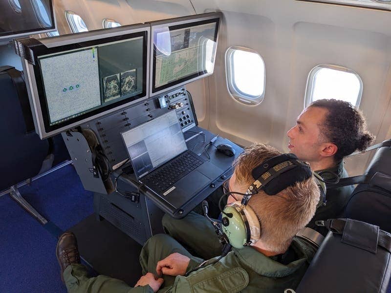
U.S. tech firm Infleqtion has test flown a new unjammable quantum navigation system that doesn’t rely on external signals to determine aircraft position. The system uses an atomic clock and “ultra-cold-atom-based quantum system” that detects changes in motion of the aircraft. It was put through its paces on a modified Avro RJ100 for a total of eight hours at Boscombe Down in the U.K. The U.K.’s Dept. of Science, Innovation and Technology said in a statement that the new system “could, over time, offer one part of a larger solution … [to] ensure that the thousands of flights that take place around the world daily, proceed without disruption.”

The U.K. is planning to deploy quantum navigation on all commercial aircraft by 2030. It’s a partial response to a wave of GPS jamming by Russia affecting flights in Eastern Europe. There have been thousands of reports, and some scheduled flights to destinations near the Russian border have been suspended by some airlines. In April a flight carrying U.K. Defense Secretary Grant Shapps was affected by jamming on a flight between Poland and Lithuania.

Russ Niles
Russ Niles is Editor-in-Chief of AVweb. He has been a pilot for 30 years and joined AVweb 22 years ago. He and his wife Marni live in southern British Columbia where they also operate a small winery.

10 COMMENTS

  1. This headline is a typical example why I am getting allergic to the “quantum” hype. Let me try to shine some light on this:
    – This system is just as un-jamable as traditional inertial inertial-reference navigation. The “quantum” aspect makes absolutely no difference to the jammability here.
    – A laser gyro is just as “quantum” as an atom interferometer based system.
    – I haven’t seen the actual residual inertial drift of this system (I bet that’s confidential information), if past experience is any guidance, I would be very surprised is it is better than traditional state-of-the-art internal navigation systems. That’s because typically some of the dominant sources of drift noise are independent of the type of sensor system.

    Here is a link for folks interested in the technical background:
    https://www.frontiersin.org/articles/10.3389/fphy.2022.994459/full

    • I basically agree with you, sballmer. Way back in the 60’s, the B-58 “Hustler” used inertial navigation with ANALOG computers using synchros and servos and differential transformers — mechanical computers. As a bomb/nav type on that airplane, I can attest to it’s accuracy. Now snap forward to today with ultra-fast digital computing, laser gyros, mems device accelerometers and couple all of that with — when available — external secondary cross-check inputs/systems and you have an even greater accuracy nav system “unjammable” because it doesn’t need GPS. Further, even my Aera 660 handheld GPS is capable of using BOTH GLONASS and the US GPS systems … a sort of cross check. I don’t know if Russia is diddling with their own GPS system but there are others, as well. I hear the Ukrainians are using portable GPS systems, as well.
      More than anything else, what’s going on in Ukraine is providing the world with a VERY valuable lesson in the folly of depending upon only GPS as a primary source of nav data. I hope the FAA is paying attention? I know they’re keeping a MONS network of ground based nav transmitters but I sure wish they would have kept the LORAN system going. I used Northstar units that I loved. They’re junk now.

  2. I agree with sballmer and Larry S. I have always been concerned about the ease of jamming lower power 1575 MHz signals from orbit with relatively low powered terrestrial jammers/transmitters.

    The FAA ignored commenters concerns about a sole source sat-nav in the 1990s and began a course that would phase out VORs, LORAN-C and other ground based navigation. Three things demonstrate the folly of this course.

    First, Loran C is a reasonable and very cost effective (cheap) radionav system which is pretty hard to disrupt except at sunset/sunrise.

    Second as the Lightsquared fiasco which still lives on, revived for several political cycles as successor purchasers of the decayed remains of Lightsquared bankruptcy assets re-attempt to get permission to transmit high power terrestrial signals on GPS guard bands. Terrestrial low power RF transmissions on these 1575 MHz bands has been demonstrated to disrupt GPS for 1500+ nm and finally lessons not learned have led to the same destructive interference with 5G cell radios interfering with radio-altimeters. It doesn’t take much money, engineering or radio savvy to build a GPS disruptor which would make us dependent on an increasing scarcity of alternative nav systems.

    I’m guessing that many younger pilots have never been on a cross country trip with the nav radios all turned off and their moving maps disabled.

    • Whatdya think they’d do, Art. I know whata they’d do … have a heart attack if they had to draw a pencil line on a chart and use pilotage to figure out where they are, which way to get to where they want to be and what time they’d get there 🙂 IF you want to finish the job … take their cell phones away. 🙂

  3. Larry S. I did when young, not so long ago, pencil line on a chart, pilotage, flight service….. the whole deal.

    The kids can do it, you did.

  4. I want my Garmin Quantum Navigator!

    I learned to fly in the 90’s. Civilian CFI’s (ex-mil) and on my own dime. GPS wasn’t available yet so LORAN was still all the rage. Pilotage and ded reckoning was all I had in my Champ. Got me up and down the entire west coast multiple times. It can be done. Even by us kids.

  5. VOR, TACAN, and ADF was how I learned, but the most fun I had was when I snapped a line on taped together sectional and flew from the Dallas area to Cortez, CO (KCEZ) … at 500′ AGL. In a Mooney. I put hack marks every 5 minutes on the chart and navigated by reference to the ground and cows, etc.

  6. Not applicable to the rest of the world, but here in the US we already have an infrastructure that would work as a reasonable fallback navigation system: the ADS-B ground station network.

    Each station has a fixed location. The broadcasts are timed to a common, highly accurate clock source. A little time-of-flight math and you should be able to figure out where you are. I’m a bit surprised this hasn’t become a product, or perhaps just a feature of existing ADS-B receivers.

    • Public radio stations are still required to transmit their station ID on a regular basis. AM broadcast antenna locations are registered and publiccally accessible information. ADFs still receive those signals. No reason we cannot all go back to that state-of-the-art technology.

LEAVE A REPLY