Kobe Bryant, Eight Others Killed In Helicopter Crash (Updated)

33

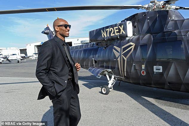
Retired NBA star Kobe Bryant and his 13-year-old daughter Gianna were among nine victims of a fatal helicopter crash near Los Angeles on Sunday. Bryant and the others were aboard a Sikorsky S-76 that went down on a wooded hillside in Calabasas about 9:47 a.m. local time. Initial reports said he owned the S-76. It is registered to Island Express Holding Corp. The group was reportedly headed from John Wayne Airport in Santa Anna to a youth basketball game at Bryant’s basketball academy in Thousand Oaks about 20 miles from the crash site.

Conditions were reported as foggy or misty at the time of the crash with visibility of 2.5 miles and ceilings of about 1,100 feet. According to ATC recordings, the pilot requested Special VFR, which was approved, and flight following, which was rejected because the helicopter was below radar coverage. The last transmission was squawking ident with Socal Approach about three minutes before the reported time of the crash. The pilot has been identified as Ara Zobayan, reported to have 8,200 hours total time.

The aircraft crashed just south of Highway 101 in a rural area and the debris field was extensive. It sparked a small brush fire that was put out by firefighters. Bryant commonly used the helicopter to commute around the Los Angeles Basin.

On Monday, NTSB investigators were on scene and mapping the area with drones. Investigator Jennifer Homendy said at a media briefing that the agency is looking for any photographs of the weather at the time of the accident, and that the NTSB was leveraging the FBI as a “force multiplier” in acquiring evidence that could help reveal the cause of the crash. “There is no criminal portion,” she said.

According to NTSB preliminary statements, the S-76’s impact occurred at 1,085 feet MSL, with a debris field of “about 500 to 600 feet.” Homendy described it as “a pretty devastating accident scene. There is an impact area on one of the hills and the piece of the tail is down the hill, on the left side of the hill, fuselage is on the other side of the hill, and the main rotor is about a 100 yards beyond that,” she told the media on Monday afternoon. The investigators are expected to be on scene through the week.

In addition, the Los Angeles Lakers have postponed Tuesday night’s game with the LA Clippers. The NBA said in a statement that “the decision was made out of respect for the Lakers organization, which is deeply grieving the tragic loss of Lakers legend Kobe Bryant, his daughter Gianna and seven other people in a helicopter crash on Sunday.”

Tuesday, FAA Administrator Steve Dickson spoke to the Helicopter Association International attendees at Heli-Expo in Southern California. “By now, everyone is aware of the tragedy that happened Sunday morning, only 50 miles northwest of this convention center. I speak for all of us at the FAA when I say that we are saddened by this accident and the loss of so many lives, and our hearts go out to the family and friends of those onboard. It is much too early to speak intelligently about why this may have happened, but suffice it to say that the NTSB, FAA and others are already hard at work to discover the causes. Despite what the investigators ultimately determine, we in this room know that all too often, helicopter accidents and GA accidents, in general, turn out in hindsight to have been preventable. I left Washington on Friday prepared to deliver a safety message here and to lead the charge for action on helicopter safety. The events of Sunday morning make that mission all the more urgent. If not now, then when. If not us, then who?”

Russ Niles
Russ Niles is Editor-in-Chief of AVweb. He has been a pilot for 30 years and joined AVweb 22 years ago. He and his wife Marni live in southern British Columbia where they also operate a small winery.

Other AVwebflash Articles

33 COMMENTS

  1. Special VFR? That implies that the pilot or the aircraft may not have been equipped for IFR flight, and the conditions were reportedly IMC along the coast. Seems like they were basically scud running, which is risky in any kind of aircraft.

    Sounds like a classic case of get-there-itis. It’s really sad.

    • I’ve been in a helicopter scud running, it is pretty hairy as you fly past the telegraph poles following the road. It was a military chopper and we were on a rather imprtant mission for the Foreign Office, hence the scud running to the High Commission to pick up our diplomat. Not recommended unless you REALLY HAVE to be there!!!

      Sfter the pick-up the chopper dropped us at a civilian airstrip so it could refuel at a VTOL only fuelling stop. Filled the long-range tank in the cabin then picked us up for a rolling take-off.

      The return journey was almost as hair-raising as the cloud base was lkower than tha peaks of the mountain range we had to traverse. The Pilots found a way through eventually after a few false starts up cloud covered valleys.

  2. If the reported weather is less, a pilot can request a Special VFR Clearance. Several conditions must be met; the visibility must be at least one statue mile, the pilot must remain clear of clouds and at night, the pilot must be instrument rated in an IFR capable aircraft.

  3. Low altitude urban flying in poor visibility is tricky at best.
    Even a minor distraction or mechanical issue can instantly be deadly.
    But we all know this.

  4. This model helicopter is capable of IFR. But, IFR also requires being at minimum instrument altitude and on a route ATC can approve in the very busy airspace along the route of this ill-fated flight.

  5. Unless rules have changed since my ATC time, SVFR can only be approved in Surface Areas of class B,C,D airspace. Without pulling up a LAX sectional, I don’t think the class B surface area covers very much territory. Sounds like they were coming up from the southeast of LAX and needed clearance through that LAX surface airspace to get up to the NW. The L.A. area has huge numbers of helicopters operating all around there constantly and have various procedures established for them. I’m guessing a pilot of an L.A. area S76 would have been very familiar with all of that and used the process frequently. So, the SVFR part was probably not an issue. The terrain does have big hills past LAX. So back to the scud running, which helicopters actually are permitted to do more so than fix wing or maybe a mechanical thing. Frank Tallman, as experienced and as familiar with the L.A. area as he was, scud running hit the hills out there and got killed.

    • I know about where this happened from a road sign and a witnesses comment in Raf’s video. Las Virgenes Rd and Mureau Rd is in an area of a lot of canyons both north and south of the 101 Freeway located WSW of Van Nuys. Even in the video, you can see raw hills. This is 15 mi east of the ultimate destination in Thousand Oaks. He had no business being down that low in that location I’m betting he was looking to find the 101 Freeway? The Flight Aware ground track ends just about where the crash occurred, too.

      See: http://www.google.com/maps/place/Las+Virgenes+Canyon/@34.1684044,-118.7076428,15z/data=!4m5!3m4!1s0x80e8273bffe268d3:0x7260536c9e4c76dd!8m2!3d34.1722273!4d-118.7023111

      According to the adult witness, the machine was producing power, was flying very low and very slow and now going eastbound … indicating the pilot was scud running and looking for something ?? But he was 15 miles east from his destination ?? Why was he so low there ??

      The witness in the video says he’d lived in the area a long time and never seen such low clouds and scud.

      What happened to Climb Communicate Confess and Comply? If the pilot had just Climbed, he’da been in VFR conditions albeit maybe “on top” So what? Didn’t we all just talk about FAR 91.3 in the fuel dumping incident. I’m wondering what sort of nav equipment or glass screens the helicopter had? Surely he’d have known he was in those hills … which are very uninhabited. Hell, my Aera 660 portable will tell me … “Terrain Terrain.”

      It appears they were headed to his Mamba Sports Academy in Thousand Oaks about 15 mi west of the crash scene. If nothing else, the pilot could have climbed and headed to the Camarillo airport which is about 10 mi west of their destination. They could have gotten ground transport from there.

      They’re touting the pilot as a “qualified” 8,200hr CFI instrument rated pilot and the S-76 surely had some good nav gear aboard … what the heck was that guy doing down in the soup around 1100′? Lots of questions here. And … flying single pilot in such conditions wasn’t very smart, either. Even if he had a private pilot aboard to help him navigate, it woulda probably gone better.

      There’s gonna be a lot to be learned from this CFIT evolution.

      • It’s possible the SAS and/or autopilot wasn’t functioning, in which case it could have been nearly impossible to maintain stability and control without outside references. Helicopters are not airplanes, so it’s possible it wasn’t as simple as “climb above the fog/cloud layer”. We won’t know if that’s the case until we get more information from the investigation, but it is certainly something to consider. It still doesn’t remove “pilot error” (i.e. a poor decision to fly at all in that weather) from the possible cause, though.

        My purely speculative guess as to why they were flying low-level VFR is that either: the required equipment for single-pilot IFR wasn’t available on-board (either not installed, or not working), OR it was available but the pilot wanted to avoid possible delays on an IFR clearance combined with the fact that they still would have had to go visual to land off-airport. And helicopter VFR limits are much lower than for aircraft (presumably because a helicopter can just slow down and is more maneuverable than an airplane).

        • An S-76 can’t be “controlled” just by reference to horizon and heading instruments? I highly doubt that. Once in translational lift, a helicopter IS an airplane. I might buy into that in a hover but not in cruise. As I said above, find the Ventura VOR and/or Camarillo airport and THEN decide if you want to descend into the soup or tell the tower you want to make a precautionary landing. And I’d additionally wonder why the Lat/Long of the destination wasn’t dialed into a GPS, too. This is nothing more than pilot error resulting in CFIT.

          • I can’t speak to the S-76 specifically, but certainly the Robinson helicopters aren’t as easy to control by instruments as with an airplane. It’s certainly possible (they are used as instrument helicopter trainers), but that pretty much requires two people (and even then, they aren’t approved for flight in IMC). I don’t disagree with the alternative you mention, but again, it could be that the required equipment for single-pilot operations wasn’t available. The radar rate of descent in the final moments does seem consistent with helicopter loss-of-control (i.e. potential rotor stall).

        • I’ve only flown two helicopters, the R22 being one of them. It is the ONLY aircraft that I can honestly say I hated. The low mass rotor system is an accident looking for a place to happen. A two turbine S-76 multi-blade helicopter is an entirely different machine. If the highly touted 8200 hr pilot was SO good, why was he flying single pilot VFR in — at best — very marginal conditions? All roads in this evolution lead to the pilot. When you’re about to smack into a hill and you pull back on the collective … you’re gonna stall … duh.

          • Probably for the same reason many other highly-experienced pilots do dumb things: they felt pressured and thought they could complete the mission, and then got locked into get-there-itis. Assuming it was a VFR-into-IMC crash, the worst part is that he could have set down almost anywhere and waited out the weather – that’s the whole point of a helicopter: that you can land in almost any spot that is a little bit bigger than the rotor diameter.

    • Looking at the VFR chart for that area, minimum safe altitude was 5,200′ The Ventura VOR could have been used to navigate either to Camarillo or Oxnard or NAS Point Mugu to get his ‘bearings’ and find the 101 Freeway. I’m seeing peaks in the area around where he went down of almost 3,000′. I’m betting that — on top of everything else — he was under verbal pressure inside the aircraft to get to the destination, as well.

  6. This accident is starting to look more and more like the Gulfstream accident in Aspen. In both cases experienced flight crew flying into weather situations that they should have known better then to fly in. Without being disrespectful of the deceased, I wonder what kind of owner Mr Bryant was to fly for? Was there “pressure” to fly into weather that the pilot should have known better than to attempt? RIP

  7. Monday morning quarterbacking is easy for those of us who think we would have performed better.Hopefully we can all learn to avoid putting ourselves in a similar situation.

  8. The Board member is a politician. The real leader of the investigation is the investigator in charge. In this case, it is Bill English. I’ve worked with Bill in the past. He is as good as they get. Someone mentioned the Aspen Gulfstream crash. Bill ran that investigation.

  9. The ADS-B data shows that the pilot had indeed intercepted the 101 freeway out near Woodland Hills, which despite its name, is fairly flat and densely populated. He intercepted the 101 from a southwesterly track because ATC had routed him north of the Burbank and Van Nuys airports, to avoid some IFR departures which were coming off to the south. He then tracks the 101 dead on all the way into the Calabasas area, which is several miles, so the indications are that he has visibility below the aircraft at this point. He’s flying at 1250 ft calibrated altitude and 130 knot ground speed heading into this area, but Calabasas is where the 101 starts winding through the hills. After the first couple of turns of the 101, the aircraft starts gaining altitude, and the pilot informs ATC that he is climbing to avoid a cloud deck. One eyewitness describes this area as “a bowl, with its own microclimates”. Tracking a ground reference, like the 101 freeway, at low altitude, high speed, and winding through hills, it may have been impossible to see an approaching decrease in the cloud ceiling until after coming around the bend. Heck, I’ve done it in a car in the mountains, on a windy road, and that’s at low speed. Came around the bend, and suddenly I’m in the soup. The climb and the initial speed decrease to 110 knots was most likely the best response if this was the case, but why the aircraft subsequently turns left and descends rapidly, will be the key for investigators to determine (if possible).

    • Yes, according to the NTSB briefing on Tuesday, the flight was operating under Part 135 charter, and according to several articles (e.g., Forbes, CNN), “Island Express Helicopters, a Long Beach-based company that has seven helicopters registered to it and a related holding corporation, is certified under Part 135 of FAA regulations to provide on-demand charter services under VFR conditions only, according to FAA records.”.

  10. I’m not a pilot, but I wonder if Artificial Intelligence is not mature enough be used to detect an erratic flight or vertigo situation and emit consequently a strong warning to the pilot, like “correct attitude/bank now” etc.

LEAVE A REPLY