FAA Deletes Foreign Information From Sectionals

50

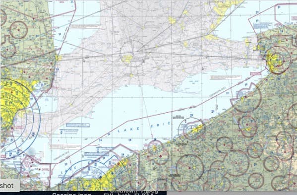
Pilots in border regions are wondering why the FAA has deleted much of the aeronautical information from non-U.S. airspace from its latest sectional charts. The late December release of the sectionals omit detailed airspace information in Canadian airspace, and the changes reportedly apply to Caribbean and Mexican regions along the border and off the coast as well. The FAA has acknowledged AVweb’s request for information on the move but has not yet provided details. The change was announced Oct. 12 in a single-paragraph Charting Notice that said the foreign areas included on sectionals would be “skeletonized.”

Until the December release, the FAA had included the same level of aeronautical information on neighboring airspace. Now, the charts in non-U.S. airspace contain only major airports, NAVAIDs and airways. In some cases, Canadian airspace, particularly in Southern Ontario and the Atlantic provinces, gets as much or more U.S. traffic as domestic use as American operators overfly Canada to get to U.S. destinations. Canadian pilot groups have also flagged the changes and are querying their authorities about it.

Russ Niles
Russ Niles is Editor-in-Chief of AVweb. He has been a pilot for 30 years and joined AVweb 22 years ago. He and his wife Marni live in southern British Columbia where they also operate a small winery.

Other AVwebflash Articles

50 COMMENTS

  1. There was an Oct 12 2022 announcement of the “22-03 VIS Charting Notice”, which says “areas outside of the U.S. shall be skeletonized”, which took place on the December 29 charts.

    Curious if there is rationale or was a discussion about it though. In a way, it makes sense, as it removes the liability or work burden from the US for non-US charts.

  2. As a resident and pilot based in eastern Maine, practically at the border with Canada, this is big step backwards. I mean, the FAA always has provided detailed chart data for Canadian border airspace before – what’s changed?

    • I agree. There are plenty of examples along the Canadian border where US ATC handles traffic in Canadian airspace (Detroit area, Windsor airport) and NAV Canada handles traffic in US airspace (Bellingham WA).

    • I, for one, am going to reach out to the FAA and express my opposition to this change. Did they provide any sort of public comment period or opportunity for pilots such as myself to provide feedback on the stripping out of valuable aeronautical information from sectionals? I don’t know the answer to that but I aim to find out. Suddenly, my paper charts and digital charts (via Foreflight) are critically less useful in the cockpit when I’m flying near or over the border. There is a safety of flight issue here. I hope that other pilots in border areas will join me in raising some hell and reversing this ill advised decision.

  3. This raises the question – do Canadian charts show data below the US border (presuming that Canada produces the equivalent of US Sectional Charts)? After this move, will the Canadians reciprocate with their chart data?
    For every action there is a reaction.

      • Actually, Canadian charts are viewable on FltPlan.com. However, FltPlan appears to prioritize U.S. charts when both Canadian and U.S. charts are selected, meaning that you see the skeletonized view of the area covered by U.S. sectionals. Simply deselect U.S. charts, while ensuring that Canadian charts are selected, to see aeronautical data for Canada.

    • I use ForeFlight with subscriptions to both U.S. and Canadian charts. Users are required to toggle between one and the other – they don’t display simultaneously. The Canadian charts (provided by Nav Canada) extend between 50 and 60 nm into the U.S. in Western Canada (from the Prairies/Central Plains to the West Coast). It’s complicated around the Great Lakes, but in Maine the Canadian coverage is as much as 100 nm south of the border.

  4. Update cycles out of sync across border after change from 6 mos to 28 day and there was concern about data integrity shown in US chart/databases?

    Not saying it’s the best way to address, but could see the logic in a concern for relaying out of date info if not coordinated across border.

  5. “Skeletonized” is an understatement, judging from the Montreal sectional. Topography, roads, and cities, towns and (sometime very small) villages are indicated, along with only the bigger airports, which themselves are indicated by circles, name and identifier (no runway length, AWOS or CTAF/tower frequencies). Other airports of landmark or emergency values have vanished. Interestingly, there’s a box that reads: “Limited chart information provided outside of US airspace…” That information would come from Nav Canada, which has been experiencing major personnel shortages (leading, for instance, to Montreal Terminal routinely denying services to VFR traffic this past summer). For those who asked, the Canadian sectional charts, though slightly different in appearance, do feature the detail you see in their US counterparts, including those charts that straddle the border.

  6. There was also an announcement that only private airports with “landmark value” would continue to be charted, and no references to those with “emergency value” would remain.
    No clue what the criteria are for one vs the other but it’s nice to know the FAA is looking out for us and decluttering our sectionals to leave landmarks but not emergency landing areas…

  7. Previous to this change, and for as long as I can remember, FAA charts depicted a note telling pilots to refer to current Canadian charts and flight information publication publications for information in Canadian airspace.

    It may well be that ensuring the accuracy of foreign aeronautical data was becoming an issue for the FAA and there may have been liability concerns. From practical point of view, charting aeronautical data in foreign states is not the FAA’s business and there is arguably a cost involved with tracking and updating foreign aeronautical data to be charted.

    What is very unfortunate, though, is a lack of uniformity between chart products developed by different ICAO states, and ease of getting them. Canadian charts use some different symbology and don’t use magenta color like U.S. charts, but are relatively easy to get. Where would your average recreational pilot get a VFR chart for Mexico, Cuba, the Bahamas, the Dominican Republic, some of the other Caribbean countries or Samoa? In Europe, many VFR pilots seem to buy charts produced by private companies, just like IFR pilots tend to use Jeppesen or Lido charts when flying internationally. This helps address the commonality and supply issue, although there is typically a higher cost involved than buying “official” charts.

    • Exactly. In EU almost every country has they sectional charts and the neighbors ones don’t have acess to the borders sectional airports of the foreign countries in they sectional charts. You must buy the charts (digitally or paper ones), although EU is union of countries. Sad things happen.

  8. This makes about as much sense as the media’s unfortunate habit of terminating weather maps, forecasts and such information at the US border. Or perhaps the next step is effectively banning cross-border overflights. Without proper charts, how is the PIC able to obtain ‘all information pertinent to the flight’?

    • The termination of Wx charts across the border is incredibly annoying If you’re flying anywhere in the region on the U.S. or Canadian side, it makes weather planning 50% longer.

  9. The cynic in me thinks this is a ploy by Foreflight (Boeing) to get more Canada subscriptions. But that would mean cooperation with/by the FAA…

    Never mind.

    • If I subscribe to Canadian instrument charts in FF do I get Canadian sectionals, or whatever they are called?

    • Matthew P., that was my exact thought as well. I just renewed by Foreflight subscription, which has always displayed full aeronautical data for the Canadian border area and suddenly — poof — it’s gone!

      I do understand that Foreflight is simply using the chart data supplied by the FAA, but I’ll be damned to pay for a product only to have said product degraded after I hand over my money.

        • Wally R., I didn’t say that it’s Foreflight’s fault – I do understand that they simply reproduce the FAA provided charts in their app.

          But my point is when you pay for a product with the understanding and expectation that it will provide the same information (chart data) that it always has, and then a portion of that information is removed after you hand over your money, I call that bait and switch. Where Foreflight sources their chart data from is irrelevant here — they are providing a degraded product as compared to past versions!

  10. This also impacts services like SkyVector which I used a lot for planning flights in Southern Ontario/Quebec/New Brunswick. You can still plan airport to airport, but many of the navaids are not there from what I can see.

  11. With the removal of all data, safety has been markedly reduced. For example, immediately west of Sault Ste Marie, Michigan (KANJ) there is Class D airspace in the United States associated with a Canadian airport (CYAM) in Ontario. The new charts do not publish any frequencies so this airspace is effectively off limits to US pilots using FAA charts. It also makes it impossible to monitor traffic coming and going in the area. This is a huge step down in safety and reduces the ability to maintain situational awareness.

    The FAA really needs to maintain a band of data in southern Canada and northern Mexico so that flights near the border can be as safe as those in the rest of the country.

    Canada’s charts extend to about the 48th parallel, 60 miles into the USA. Ours need to extend into Canada by a similar amount. The FAA is already aware of this principle. The San Francisco Sectional overlaps the Klamath Falls Sectional by a small amount. All other FAA VFR charts are similarly overlapped.

    We need chart overlap into Canada and Mexico.

    • Starting with my area FSDO, I am contacting the FAA to find out the reasoning behind this terrible decision and to request that it be reversed.

      I hope that all other pilots, especially those who regularly fly near or over the border, will likewise let the FAA know that the removal of so much data from the sectional charts is a serious safety of flight issue and that the aeronautical data in border areas must be restored.

      If enough of us make a stink, we may be able to prevail — if we don’t at least try, then what will be the next cut GA pilots will suffer?

      • It would be interesting to know where AOPA stands on this issue. Aren’t they supposed to represent our interests with the FAA?

  12. If it ain’t broke, don’t fix it!
    Did someone in the FAA not have enough to do? “Hey, I have an idea, let’s give pilots LESS information!! that’s it!”

  13. Also, another little know memo from September 8, 2022 states…
    “Private Airports Charted on VFR Aeronautical Charts
    Effective November 3, 2023, Visual Flight Rules (VFR) aeronautical charts will no longer
    make reference to emergency value in private airport charting.
    Only private airports with landmark value will be retained and charted beyond February 23,
    2023.”

    It seems like the FAA is putting out these memos of changes in hopes they stay under the radar until the changes are made….

    • Richard H., I just found out about this second issue from AOPA when I called earlier today to bring to their attention the removal of Canadian border chart data.

      I’m hopeful they will take up the cause (along with all us pilots) and bring some pressure on the FAA to undo these wrong headed changes.

  14. I’m sure that the FAA has found it as hard to work with NAVCanada is I and MANY OTHERS have. My own METARmaps.com and I’m directly affected by this change. ;-(

  15. Russ, you buried the lead.

    Private airfields to be eliminated from sectionals, safety concerns rise among pilot community for their emergency use.

  16. As a Canadian this is somewhat disappointing and head scratching, especially with two of the sectionals being named after Canadian cities (Montreal and Halifax). Are those names going to be changed? We don’t really have an equivalent since our VNC’s and VTC’s, which are not easy to obtain without cost, are rarely updated as years can go by between updates.

  17. Oh jeez I just wasted a few hours over the weekend trying to figure out why some restricted airspace near the us/Mexican boarder on the Mexico side was missing, that I know I have seen many times flying through there.

  18. Hopefully anyone concerned is writing or calling the FAA, aviation organizations, etc. to let your voices be heard.

LEAVE A REPLY