


")


")


| NOTE: Air Chart Systems atlases, NOS IFR charts and plates, NOS Sectionals, WACs, Terminal Area Charts and other chart products may be purchased online. |
I‘ve got a confession to make. I’ve flown at least a hundred transcontinental trips during the past thirty years and, more often than not, I’ve flown them with outdated charts. There…I finally said it!
Let me assure you that I’m not proud of this. It’s really rather embarrassing, and not a terribly bright thing to have done. In retrospect, I’ve been lucky not to have gotten into hot water over it. But I suspect a lot of you may be in the same boat.
My home base is in California, but three or four times a year I make a long cross-country trip. The last one took me to Cincinnati, Oshkosh, Oklahoma City, and Austin. The one before that hit Tucson, Dallas, Mobile, Miami, Raleigh-Durham, Washington DC, Boston, Cleveland, and Omaha. Trips like these require a lot of charts.
IFR Charts: Jeppesen vs. NOS
Every year I agonize over whether I should expand my Jeppesen Airway Manual subscription from its present west-coast-only coverage to full U.S. coverage. And every year, I sheepishly decide not to do so. For one thing, I tend to gag at the cost, which comes to around $600.
 But it’s not just the cost…it’s the updating hassle. I find it a collossal pain to keep my lowly west coast coverage updated, and I simply can’t face the burden of keeping a set of full. U.S. Jepp books up-to-date…laboriously filing thousands of update pages each year, 99% of which I’ll never use. And paying Jeppesen dearly for the privilege. Ugh!
A few years ago, Jeppesen came out with an alternative for folks who hate to file updates and don’t mind spending money. Jeppesen’s “Q-Service” involves getting biweekly updates that are filed in a separate binder. Every eighth update cycle, Jeppsen sends out a whole new set of charts, and you throw out all the old ones (enough to give your trashman a hernia and kill off a lot of innocent trees). Full-U.S. Q-Service costs around $800 a year, and involves lugging around an absolutely ungodly number of binders…two big heavy flight cases full of them.
NOS IFR charts are even easier than Q-service: every 56 days you get a whole new set, and you pitch out the old ones. Full-U.S. coverage from NOS is quite a bit less expensive than Jepp’s Q-Service, but still far from cheap at $522 a year.
For many years, I wrote off NOS charts because I hated their bound approach books, their tiny airport diagrams, and their hideously user-unfriendly organization (plates alphabetized by airport name rather than city name, SIDs and STARs in separate books, etc.) But over the years, NOS has gradually improved their plates and charts to eliminate these annoyances, and lately they have even offered plates in looseleaf format (although Jepp afficianados say they drill the holes on the wrong edge).
Today, NOS IFR charts are a far more attractive alternative to Jepps than they used to be. Still, $522 is still a chunk of change for charts (particularly today when you can get an entire encyclopaedia on CDROM for under $50).
VFR Charts: Sectionals & TACs
 And that’s just for IFR charts. The prudent pilot also carries VFR charts for those times when thunderstorms make VFR the only safe option, or when the engine quits and you gotta land somewhere quick, or when the weather and scenery are just too darn pretty not to fly low and slow. Did you ever calculate what a full set of U.S. VFR charts cost? For the continental U.S. only (excluding Alaska and Hawaii), there’s 37 Sectionals Charts at $7 each, plus 27 Terminal Area Charts at $4 each. All updated twice a year. That comes to around $700! Plus a third big heavy flight case to lug around.
Unwilling to pay more that $1,000 a year for charts I might never need, I’ve been taking the cheapskate’s way out for years…flying with a rag-tag collection of outdated Jepps purchased as trip kits or bummed from my rich Q-Service-subcribing friends, supplemented with an occasional NOS book purchased here and there along the way at local pilot shops, plus an occasional approach plate that was FAXed or Xeroxed in an emergency. And instead of subscribing to Full U.S. Sectional and Terminal Area charts, I’ve typically been going without VFR charts at all. Not legal. Not smart. Shame on me!
Howie Keefe’s Alternative
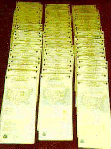
 I’ve long been aware that there’s a third alternative to Jeppesen and NOS…Howie Keefe’s Air Chart Systems. But to be perfectly honest with you, I’ve never taken Keefe’s charts seriously until recently. It’s because of those, umm, unusual-looking advertisements that have appeared for decades in just about every major aviation magazine.
You know the ads I’m talking about. Those stark-looking black-and-white ones that have about 100,000 words of ad copy set in six point type, and no graphics or artwork except for tiny thumbnail photographs of Bob Hoover, Burt Rutan, Bobby Allison, Najeeb Halaby, Julie Clark, and other illustrious members of the “Air Chart Systems Advisory Staff.” Plus that tiny little order form crammed in the corner that looks like it would take a high-powered magnifier plus a Ph.D. in math to decipher.
I guess those ads appeal to some pilots, because thousands of them subscribe to Air Chart Systems. But frankly, the ads turned me off. Somehow I figured that if Howie’s charts looked anything at all like Howie’s ads, I wasn’t much interested.
Well, last year I had the opportunity to get my hands on a set of Air Chart Systems atlases, take a close look at them, and fly with them. What I found was that my preconceived notions were just plain wrong.
 Keefe’s charts are high quality, innovative, clever, user-friendly…and at less than half the cost of the competition, a terrific bargain. Especially for someone like me who flies just a few long trips a year and wants his charts to be current and legal without having to spend a fortune or hire an assistant to keep charts updated.
What few weaknesses I found in Keefe’s system when I first flew with them in 1995 – too many chart atlases and lack of full-color topographic charts – have been entirely corrected by the improvements introduced by Air Chart Systems in 1996: What used to take four atlases is now contained in three, and the magnificent new topographic atlas contains reprints of WACs and Sectionals in full color.
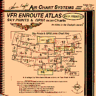
There are two essential ingredients to the Air Chart System concept: three 11″-by-11″ spiral-bound chart atlases (IFR, VFR, and Topo), plus a unique updater service that keeps the system up-to-date and legal. Let’s look at each of these in sequence.
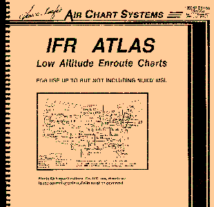
The IFR Atlas
The IFR Atlas contains all the charts needed for enroute IFR navigation anywhere in the conterminous U.S. (excluding Alaska and Hawaii). Specifically, the book contains full-size reproductions of:
- all 27 NOS low altitude enroute charts (L-1 through L-27)
- all 12 NOS area charts
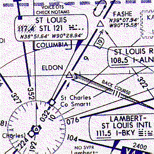
The charts in the IFR Atlas look precisely like the NOS enroute and area charts, but with two significant differences:
 First, the charts are printed in one color only (blue on white). NOS charts use a second color (brown) for VFR-only airports and NDBs, while the Atlas shows these in blue and denotes VFR-only airports by means of a slash-line through the airport symbol.
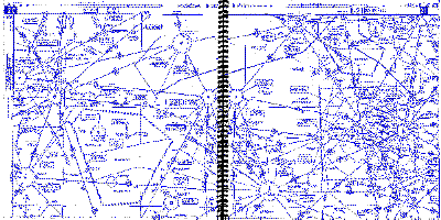
Second, instead of being accordion-folded, each NOS enroute chart is divided into four sections, each occupying a pair of facing pages in the Atlas.
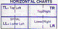 The sections are arranged so that you only need to turn one page to go east or west, and to turn two pages to go north or south. There’s plenty of overlap between adjacent sections, which makes it easy to transition across section boundaries.
 The one color printing goes a long way to help keep the cost down, and in my opinion there’s no sacrifice in readability. Air Chart Systems uses top-quality paper in their atlases, and the printing is razor-sharp (as you can see from this close-up that I scanned). If you’re like me, you won’t miss the second color at all.
Although 95% of the IFR Atlas is taken up by enroute and area charts for the continental U.S., it also contains plenty of other useful goodies:
- A user’s guide page containing a table of contents and explaining how the enroute charts are sectioned.
- A VOR locator and planning chart that covers the entire continental U.S. on a pair of facing pages, with state boundaries, city locations, enroute chart coverages, and the location of every VOR in the country.
 VOR listing, alphabetized by facility name, listing the identifier and lat/lon of every VOR in the country.
- MOAs listed with their data.
- Reprints of the air/ground voice communications panels from all NOS enroute charts.
In all, the IFR Atlas contains about 240 pages in the 11″-by-11″ format. The size is too large for a kneeboard, but feels just right sitting on your lap. The book contains all the information you need to conduct the enroute portion of an IFR flight anywhere in the continental U.S.
The VFR Enroute Atlas
The VFR Enroute Atlas is largely devoted to two series of charts intended for VFR enroute operations:
- Sky Prints charts (for VOR direct)
- GPS/Loran charts
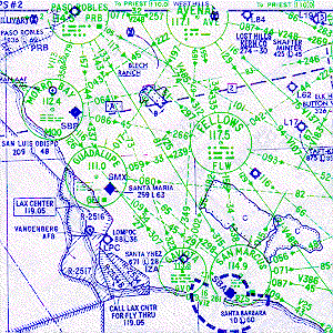 The “Sky Prints” charts are designed for VFR flight via VOR navigation. These can be thought of as “low altitude enroute charts for the VFR pilot.” There are 26 charts, each on a pair of facing pages, with the same coverages as NOS low altitude enroute charts.
Sky Prints are printed in two colors (black and green) and depict airports (with their identifiers), VORs, and special-use airspace, but almost no terrain features (other than shorelines). All Victor airways and direct VOR-to-VOR routes are pre-plotted with frequencies, radials and distances. At the top are tables containing comm frequencies for each towered airport, FSS frequencies, and center frequencies.
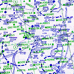 The GPS/Loran charts look very much like Sky Prints, cover the same 26 areas, are printed in the same two colors (black and green), and share the same easy-to-read and uncluttered look. But the GPS/Loran charts omit Sky Prints’ VOR compass roses, Victor airways, and VOR-direct route lines.
In their place, the charts feature a one-degree lat/lon grid (with 5-minute tick marks), highest elevation rounded up to the next 1,000 feet (the circled numbers in the upper right corner of each grid square), plus VORs (with ID and frequency) and major enroute fixes. Like Sky Prints, the GPS/Loran charts also show airports (with IDs) and special-use airspace.
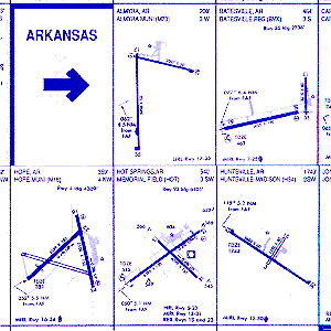 In addition to the Sky Prints and GPS/Loran charts (which make up most of the book), the VFR Enroute Atlas also includes airport diagrams (about 1″ by 2″ each) for nearly 1,500 multi-runway airports with IFR approaches, a few of which are shown at right.
The book contains a whole slew of other useful information:
- A user’s guide page containing a table of contents and explaining how the Sky Prints and GPS/Loran charts should be used.
- A VOR locator and planning chart…the same one as in the IFR Atlas…that covers the entire continental U.S. on a pair of facing pages.
- VOR encode and location table, alphabetized by facility name, listing the identifier and lat/lon of every VOR in the country.
- A nifty mileage chart showing distance in NM between pairs of major U.S. cities.
- An airport directory cross-reference table, alphabetized by airport name, showing city, state, and airport identifier.
 A page of mountain flying tips.
- A large chart of the Grand Canyon special flight rules area.
- A METAR/TAF weather decoding “crib sheet.”
- A table of all the NDBs and LOMs in the country, with identifier, frequency, and lat/lon.
- Six area charts which are essentially magnified pieces of Sky Prints charts for major terminal areas.
- A map of all Flight Watch (EFAS) outlets in the continental U.S.
- And much more!
In its 170 pages, the VFR Enroute Atlas provides all the information you’ll normally need for the enroute phase of most VFR cross-country flights. But for flights at low altitudes in mountainous areas or other “obstacle-rich environments,” you’d really like to have full-color topographic charts (Sectionals or WACs), and these are also very nice to have for dealing with IFR emergencies. And that’s precisely what Air Chart System’s newest atlas provides.
The Aviation Topographic Atlas
The Aviation Topographic Atlas is a magnificent book that contains full-color reproductions of all the WACs and Sectionals (enhanced to serve as Terminal Area Charts) that you need to fly VFR anywhere in the continental U.S., Bahamas, and Baja California (Mexico). It also includes all tower, ground and approach frequencies, as well as a flight planning map.
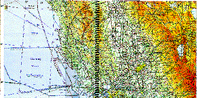 Nearly three-quarters of the Atlas is devoted to full-color reproductions of WAC charts. These are arranged as 76 two-page spreads, each covering an area of approximately 150 by 300 nautical miles. Each spread clearly indicates how to find the four adjacent neighbors. There’s plenty of overlap between adjacent spreads, making it easy to fly across spread boundaries. And a key chart at the front of the Atlas makes it easy to go directly to the two-page spread you need without having to search for it.
Once you get the hang of it, you’ll find using the Atlas far more convenient that unfolding an refolding WAC charts in the cockpit. At least I did.
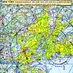 The remainder of the Topographic Atlas is devoted to detailed charts depicting every Class B and Class C terminal area in the continental U.S.
For Class B airports, at least one full page is devoted to a full-color reproduction of the Sectional Chart enhanced with Class B boundary information, radials and DME arc distances to serve as a Terminal Area Chart. Many of the more complex Class B airports have a two-page spread, and the Los Angeles area (the most complex and busy airspace in the world) is given three pages!
Each Class C airport area receives at least a quarter-page (sometimes more) containing a full-color reproduction of the airport area from the relevant Sectional chart.
What About Updates?
The most unusual aspect of Air Chart Systems is how they are updated. Keefe’s unique approach to updates seems unorthodox at first, but it’s the secret that makes the service so inexpensive and so easy to use for pilots like me who fly long trips only once in a while.
The Air Chart service includes just one set of atlases and approach plates per year. For example, the basic IFR service includes a once-a-year copy of the IFR Atlas (which comes out each May), plus a once-a-year set of regular NOS approach plate booklets (17 NOS booklets cover the continental U.S.). Most users also opt to include the VFR Enroute and Topographicatlases in their service, and these also are issued each May.
For those who start their service in the middle of the May-to-May cycle, Air Chart Systems gives full pro-rata credit at the first renewal.
Revisions consist of “updater” notices that arrive every 4 weeks on the standard FAA 28-day update cycle. There are two of these updaters, one with enroute data and one with approach data. Each successive updater is cumulative – it includes all the changes that have occurred since the previous May – so whenver you get the new updater, you simply toss the old one out. The enroute updater service works with either the enroute atlases or conventional NOS IFR enroute charts.
 The real beauty of this system is that there’s no constant updating required. When the updaters arrive in the mail, you simply file them in a pocket provided at the back of any of the atlases and discard the previous updaters. You only need to look at the updaters when you actually plan to fly a trip.
The “enroute updater” includes a big map of the continental U.S. that lets you see at a glance where changes have occurred. It takes just a moment to determine whether any of the updates affect the trip you’re about to fly. Most of the time they don’t. But if the map shows that there has been a revision for an airport, navaid or airway that you’re planning to use on your trip, you simply check the tabular portion of the updater to get the full details of the revision and mark the change right on the relevant atlas charts in pencil or pen. Mostly, the revisions are simple navaid or comm frequency changes.
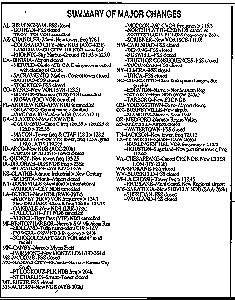 The “approach updater” includes a small box which summarizes major changes, organized by state, so you can quickly determine whether your departure, destination, or alternate airports are affected. If they are, you can find the full details in the big tabular listing (again organized by state) and mark the necessary changes on the approach plate. The listing is quite similar to the “Chart Notams” section of a Jeppesen airway manual.
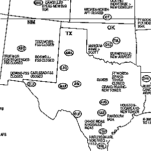
When warranted, the updaters also include “Vis-aid” graphics for any complicated changes. For example, the September 14th enroute updater that I’m looking at right now includes a revised diagram of the Charlotte NC Class B airspace area, plus a graphic depiction of the special arrival procedure for AOPA Expo in Atlantic City NJ.
Every year in May, you get a whole new set of atlases and approach plates, toss the old ones out, and the process starts over again.
The thing I really like about this system is that it’s so darned efficient. Keeping my Jepp subscription updated takes hours of mind-numbing filing of update pages, and I’ve always been frustrated by knowing that I’ll never actually use 99% of those update pages that I file. The NOS and Q-Service approaches eliminate much of the updating labor, but they involve shipping and then throwing away huge amounts of paper every 8 or 16 weeks, most of which you’ve never looked at, killing a lot of trees, and costing a lot of dough. They seem to be designed to enrich the U.S. Postal Service at the expense of the subscriber.
I only fly three or four coast-to-coast trips a year. So with the Air Chart approach, I can go for three months at a time without paying any attention to my non-California charts, then spend maybe five minutes checking the updater and making note of any revisions that will affect my trip. Most of the time, there aren’t any. The average approach plate changes only once every two years, so if you pick a plate at random mid-way through the revision year there’s at least a 75% chance it won’t have changed at all. Yet a full U.S. Jeppesen subscriber will probably have to file more than 3,000 revision pages a year to keep his Jepp books current. No, thanks!
If, heaven forbid, there’s some massive mid-year change to an approach that I fly a lot (such as my home base) or I should happen to mangle a plate (like the time my pen exploded in-flight), I can send a SASE to Air Chart Systems and get a copy of any plates I need for a dollar per airport. They’ll even FAX plates to you if you’re in a bind.
Capt’s Guide
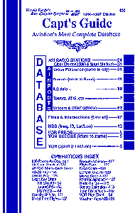 Air Chart Systems also offers a nifty little 5″ by 8″ book called the Captain’s Guide. Its 128 pages are jammed with tables of airport, navaid, and other handydata, including:
- 800-numbers for most major hotel chains, car rental companies, and airlines.
- Tower, ground, clearance, and approach frequencies for all tower airports in the continental U.S.
- VOR decode table, alphabetized by identifier, with facility name and frequency.
- VOR encode table, alphabetized by facility name, with identifier and lat/lon.
- .NDB table, including frequency, identifier, and lat/lon.
- ILS and LOM table, including frequency and identifier.
- My favorite feature: A table of AM radio stations by city, with call letters, frequency, and power output. Also a separate table of 50,000-watt clear channel stations, and another table of sports broadcast stations for every major-league team in the country. (Who said ADFs were obsolete?)
- Airport cross-reference table, alphabetized by airport name, including city and identifier.
- Airport decode table, alphabetized by identifier, with city, state, and airport name.
- Airport directory with city name, airport name, identifier, distance and direction from city, airport elevation, length of longest runway, unicom and CTAF frequencies, and lat/lon.
- Table of lat/lon data for every low-altitude intersection.
- And much more!
What Does It Cost?
For pilots like me who fly long trips and need wide chart coverage, you can save a bundle by using Howie’s charts.
The basic Air Chart IFR service for the entire continental U.S. costs just $229 a year. This includes enroute charts (the IFR Atlas), approach plates (20 NOS books), and the 4-week updater service for both. A set of binder rings for the 20 loose leaf NOS books cost an additional $25. Approach plate books are also available in NOS’ gum-bound format for the same cost.
By comparison, a Jeppesen subscription for the same coverage costs $541 for the initial charts and first-year updates, $135 for plastic binders (or $300 for leather ones), and about $400 a year for subsequent revision service…not counting labor, of course. For Q-Service, the cost is nearly $200 per year more. A NOS subscription costs $522 a year (plus $20 for binder rings).
Air Chart Systems offers five package-deal chart kits:
- Basic VFR Kit: Includes two atlases (VFR Enroute and Topographic) with 4-week updater service…$119/year.
- VFR Deluxe: Includes two atlases (VFR Enroute and Topographic) plus Capt’s Guide with 4-week updater service…$149/year.
- Cockpit Library: Includes all three atlases (IFR, VFR Enroute, and Topographic) plus Capt’s Guide with 4-week updater service…$189/year.
- Basic IFR Kit: Includes IFR Atlas and full-U.S. NOS approach plates with 4-week updater service…$229/year.
- Deluxe Library: Includes all three atlases (IFR, VFR Enroute, and Topographic) plus Capt’s Guide and full-U.S. NOS approach plates with 4-week updater service…everything they have, over $1,000 worth of charts!…$329/year.
The company also offers a wide range of chart products a la carte for those who want to custom-design their own chart service:
- Individual chart atlases (IFR, VFR Enroute, or Topographic) cost $89 with 4-week updater service. The second atlas you buy costs $59, the third $49. (If you’re buying more than one atlas, the packages above are usually a better deal.)
- A subscription to NOS low-altitude enroute charts (unbound) costs $275.10 for full U.S. coverage, or $179.55 for eastern or western U.S. only. This includes one set of NOS charts plus a year’s subscription to the 4-week enroute updaters. (But I think the IFR Atlas is a better way to go…and it costs less, too.)
- A subscription to NOS high-altitude enroute charts costs $74.55 via NOS subscription.
- NOS approach plates cost $50/year for any one of the five coverage areas, $95 for two areas, $130 for three, $155 for four,or $180/year for full-U.S. coverage. This includes one set of NOS approach plate books plus a year’s subscription to the 4-week approach updaters.
- Sectionals and WACs (unbound) at $7.25 each, and VFR Terminal Area Charts at $4 each. Air Chart Systems offers a 15% discount on orders of $20 or more (net).
- The Air Chart Systems 4-week updater service alone (without charts), $45/year for enroute only, $50/year for approach only, $85/year for both.
Approach Plate Options
 The basic IFR service from Air Chart Systems includes seventeen looseleaf NOS approach plate booklets that require ring bindings ($25 for twenty sets). The rings are non-magnetic (plastic) and reusable. For $10 more, Air Chart can offer you twenty “book buddy sets” that include ring bindings and three clear plastic plate protectors. The covers help keep the books in good shape, and are definitely worth the extra ten bucks.
For users who don’t care for ring bindings, Air Chart also offers the standard NOS books with a gum binding for the same cost. One big advantage of the gum binding is that the books store much more compactly in your flight case without rings.
![]()
Conclusion
The Air Chart Systems approach is quick, easy, cheap, and legal. There are probably a lot of “chart snobs” out there who look down their noses at the idea of marking up charts and approach plates by hand. I know…I used to be one of them. But after filing Jepps for 30 years and sometimes flying on illegal outdated charts, I’ve concluded that Howie Keefe’s system is a winner.
The $329/year “Deluxe Library” package meets my needs perfectly. It provides me everything I need to fly VFR or IFR anywhere in the country. To get the same coverage with Sectionals, TACs, and NOS or Jepp subscriptions would cost me well over a thousand dollars ayear. The cost savings is enough to buy a nice handheld GPS. It’s really a helluva deal.
And I promise…no more flying on hand-me-down out-of-date charts!
Order  Charts On-Line!
You can purchase Air Chart Systems atlases, NOS IFR charts and plates, NOS Sectionals, WACs, Terminal Area Charts and other chart products on-line right here, and help support continued free access to AVweb and AVflash in the process. Most orders are shipped the same day received. If you need aviation charts (and what pilot doesn’t?), we’d sure be grateful for your patronage!
QUESTIONS? Call Air Chart Systems at (800) 338-7221 or (310) 822-1996.
