The acting executive director of the European Aviation Safety Agency says aviation regulators need to be involved in the design of satellite navigation systems to counter the growing problem of GPS spoofing. But Luc Tytgat told a forum on the issue in Europe last week that for now civilian victims will have to be vigilant. “We immediately need to ensure that pilots and crews can identify the risks and know how to react and land safely,” Tytgat said in a statement. “In the medium term, we will need to adapt the certification requirements of the navigation and landing systems. For the longer term, we need to ensure we are involved in the design of future satellite navigation systems.”
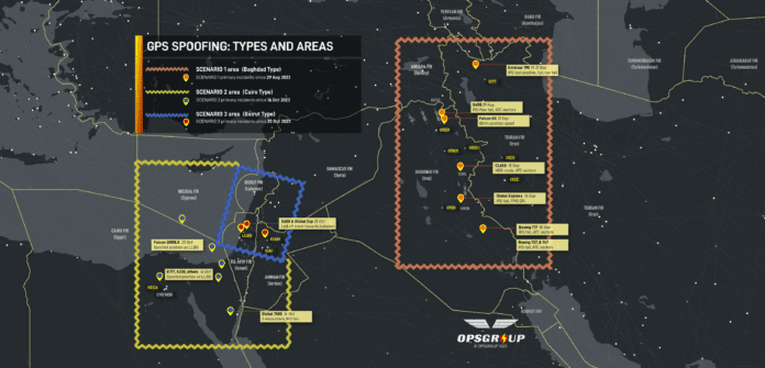
For the last six months, airline and other civilian pilots have reported incorrect data corrupting or crashing their navigation systems. In many cases, their onboard gear has been tricked into giving the incorrect position of the aircraft, sometimes hundreds of miles from where they’re actually flying. It started in an airway near contended airspace near the Iraq border, but there have also been reports in other areas of the Middle East and eastern Europe and over the Arctic.


























VOR resurrection+D-GNSS and CNP.
Well over Iraq & Turkiyë we had jamming and spoofing that disabled both onboard GPS units for the remainder of the flight to LHR Luckily we had triple IRS feeding our FMS’s.
Also the spoofing on the way back over Iraq intermittently disabled the terrain awareness & TCAS system. Then both radars went offline for 10 minutes. It’s getting progressively worse.
It still amazes me we can get such accurate signals from light-bulb levels of transmission more than 12 miles away! Also not surprised they can be corrupted by the malevolent.
I am surprised aviation authorities think it’s OK to rely on these and are shutting down alternative radio navigation aids.
Try 12,000 miles away, and you’re right. Creating interfering RF more powerful than GPS will always be possible. The need for public specs makes typical counter-EW mechanisms like frequency hopping virtually useless.
Is a more accurate and reliable inertial nav possible? Inertial Nav is impervious to outside jamming. The old IN systems used electro mechanical gyros and accelerometers, which were very expensive, bulky, and would drift excessively over time. Are modern solid state gyros and accelerometers good enough to create more reliable and cheaper inertial nav systems? Anyone know?
Even though modern laser gyro inertial navigation technology is incredibly accurate, their drift rate may be as high as 2NM/hr according the Honeywell manual for the Laseref, and therefore need the GPS update input, or a manual update over known coordinates such as a nav/aid. Not enough to achieve the accuracy required for PBN (Performance Based Navigation).
This hybrid IRS/GPS system is the standard of today’s navigational equipment, so yes, GPS dependent. Pilots are currently experiencing jamming and spoofing in the Middle East region. Many choose to deselect the GPS input prior to entering the problem areas and not wait for jamming/spoofing to wreck their cockpit. Once your present position is compromised, you must get vectors to remain on course. Often happens overwater without VOR availability.
Back to other navigation systems aids, such as maps and compasses? No subscription fees, no upgrades, no batteries. Follow the #3 graphite core pencil line.🤔
Personally I’d love to have a backup via star tracker like the SR-71, but magnetic navigation (using maps of the Earth’s magnetic field to determine position) seems to be a promising alternative as well. In whatever the short term for certificated electronics is, more warnings about discrepancies between GPS and other sensors and a logic that does not prioritize GPS as “more accurate” would help.
As one who flew (ha) HAWK missiles at their early deployment I am not surprised. We were immediately countering counter measures. We did succeed. They counter our measures, repeat, repeat…
China now seems to be the lead manufacturer of electronic devices. Design follows manufacturing eventually. When China supplants Silicon Valley they will be able to interfere or shut down electronic systems for prolonged periods at will, even for economic (military-economic?) reasons. OK, I learned to fly in a ten year old metal spar 65 HP J3 so I know that you can fly with no electrical system but I never had the skill to fly an F4 without electricals. This I know because when learning to fly instruments (spanking new C172N) my excellent instructor was and AF type who had never had a total electrical failure. When the 172’s system failed (first 100 hours remember) he turned and said something to the effect your are in the left seat and are PIC. After following all proper procedures we were never recognized by Elmendorf AFB (Anchorage) tower so finally I just landed. We were greeted by massive first responders with weapons drawn. Then I knew why I was PIC. After talking thing over it was decided that this was just a great training exercise and not really a reportable incident. In such a case it is better to be Army than AF because the AF thinks Army are just grunts but politicians in the AF were smart enough to grab upper end artillery (missiles) for the AF or they would almost be out of business these days. Note the the Continental Army used cutting edge missiles during our Revolutionary War. OK, it was mostly captured British stuff.
The FAA has already installed thousands of brand new (relative) NDBs that could be used for navigation. ADS-B Ground Stations.
Their locations are well surveyed, documented and already published on some electronic maps. They emit data, to include specific call signs.
Timing signals, triangulation and suddenly you’re navigating. Maybe throw in rudimentary AHRS data (accelerometers) for a just-enough-to-get-you-there, poor mans INS and I think you’ll have something.
The toughest thing I see, is the timing signals. With GPS being currently used as a de-facto timing source, and it out of the picture, you’ll need another. Perhaps some WAAS type timing station to compensate and monitor for atmospherics.
ADS-B stations as a complementary source, sure. But it’s still an RF modality subject to RF jamming. And it’s relatively high frequency and low power. As a backup or alternative, you want something lower frequency and higher power like the old LORAN stations. A new standard, eLORAN, was developed but then killed in the 2000s. I believe there are some eLORAN stations in Europe and the Mideast. With ADS-B, you’d probably do multilateration not triangulation unless you can DF the stations. You don’t need an accurate absolute timing reference for that just an accurate relative timing reference. If you need an absolute time reference, in many places around the globe there are low frequency time signals. One here in the US is WWVB. It has a frame rate of 1 minute. But onboard clocks won’t drift that fast. The real hurdle for timing is cellular networks. They stop working after about an hour or two due to timing drift, a those LF time sources don’t always reach during the day. On the other hand, there are special GPS antennas that can block out jammers on the horizon, and you can designed antennas to only look up.
Give me my trusty Kollsman periscopic sextant relied on for decades to get our B52s to Russia and back. Un-spoofable and no emissions to be detected by the Riskies.
GNSS is always going to be vulnerable to jamming due to its inherently low power. It used to be that you could rely on the fact that there’s GPS, Galileo, GLONASS, Beidou, etc. It was hard to jam all of them because of the occupied bandwidth. Now, the Russians are making high-powered broadband jammers. The spoofing problem is more tractable. Back in the 2000s, the community was looking at GPS alternatives because they knew this was coming. There’s a report often called the Volpe report from the early 2000s that outlined the issues and potential backups to GPS. The best alternative they identified is a technology called eLORAN, which is an update to the older LORAN-C. The timing reference met Stratum I requirements, and you no longer needed LORAN chains. Each transmitter acted like a ground-based satellite, and nav equipment would do pseudorange calculations just like with a GPS satelitte. eLORAN was good enough for RNP 0.3, which allows for non-precision approaches. I think it was Collins that made a prototype GPS-INS-eLORAN nav unit. While GPS has higher accuracy (error), eLORAN has higher precision (standard deviation of the error). Put all of that in a Kalman filter, and you have a rock solid nav solution. The nice thing about eLORAN as a backup to GPS is that it’s terrestrial based and HIGH power. It’s really hard to jam it. But there was some idiot career box checker in the Dept of Transportation who had something up his butt about eLORAN and decided to kill it. And here we are. On the military side of things, we are looking at a variety of other navigation modalities including visual (matching pictures taken with reference imagery like Tomahawk does) and magnetic fields. Celestial navigation units are still relatively large and inaccurate.