


")


 Driggs, Idaho, is in southeastern part of the state,northwest of Jackson Hole, Wyoming, and on the opposite side of the majestic Teton range.The short, scenic Teton Pass provides easy highway travel between Driggs and Jackson (mostof the year, at least), and many find Driggs an attractive alternative to the congestionand high prices that have characterized Jackson in recent years. In the winter, some ofthe best skiing in the West can be found in the Tetons; in the summer, the Teton Riveroffers perhaps the best fly fishing on the planet.
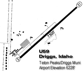 The Driggs Municipal Airport (U59) is a nice facility with a7300-foot lighted runway and a friendly FBO (Teton Aviation Center). Its major shortcoming- both for fly-in visitors and for pilots like me who are based in the area – has beenthe lack of an instrument approach. Because of Driggs’ mountainous location, none of theterrestrial navaids in the area were suitable for getting into or out of Driggs on thegauges.
But with the advent of GPS and the availability of approach-certified GPS receivers,almost every airport should be able to have an instrument approach, right? Well, yes, butit’s not as easy as it looks. This is the story of the unbelievably frustrating 18 monthsthat I spent trying to get a GPS approach for Driggs.
First, we deal with the FAA…
 The FAA Flight ProceduresOffice in Seattle took a little over a year to design and draft the new Driggs GPS-Aapproach. I expected that. By July 1996, they told me that the new approach was ready forprime-time, that had been sent to Oklahoma City for publication, and that commissioningwas imminent. Little did I know that it would be another eighteen months and a few dozenphone calls later before I could try flying that approach.
The first hitch was that although the approach had been drafted, turned out that theFAA had no approved criteria for instrument departures without the use of terrestrialnavaids. It took eight months and constant pressure to resolve that problem. Then itturned out that while all this approach design work had been going on, the FAA forgot toget the airspace around the airport reclassified from Class G to Class E as required, andthis threatened to delay things for many more months. Fortunately, the there was ascheduled FAA fly-in event at Driggs in July 1997 that generated some internal pressure onthe bureaucrats to get things sorted out relatively quickly. Political pressure from Idahocongressmen and Vice President Gore’s office may have helped, too. There were a few morecomplications, too, like getting the FAA to flight-check the approach, and meeting therequirement to get a dual altimeter system (or AWOS-1) installed at the FBO to provide anapproved altimeter setting.
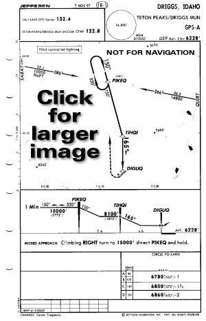
But finally, an honest-to-god approach plate for the GPS-A approach at Driggs arrivedwith my November 6, 1997, revisions. On November 7, I decided to go try to fly theapproach. Guess what? My approach-certified TSO C129 Garmin GPS-165, updated with the verylatest Jeppesen NavData card, told me that there were no instrument approaches at U59.Wonderful!
…and then, with Garmin!
 I called Garmin technical support and was told that my GPS-165 did not have thelatest software that would allow it to fly stand-alone (non-overlay) GPS approaches. IFedEx’d my GPS-165 and two others to Garmin for a software transplant.
A few days later, Garmin tech support called to say that the new software wasinstalled, but the receivers still couldn’t find the Driggs GPS-A approach because thatapproach was not on the Jeppesen NavData cards. The receivers (with their new software)were shipped back to Driggs, and Garmin said they’d check with Jeppesen on why the Driggsapproach was not on the datacard.
 After several days, having heard nothing from Garmin, I called Jeppesen directly tofind out what was going on. Jeppesen told me that the Driggs approach was not on thedatacard because Jeppesen had received instructions from Garmin not to include anycircling GPS approaches on NavData cards prepared for Garmin receivers!
A call to the NavData guru at Garmin revealed that Garmin’s software developers neveranticipated that there would be any GPS circling approaches (there are presently 37 suchapproaches in the U.S.), and that they did not provide a “data type” in thesoftware architecture to accept such an approach. That’s why Jeppesen was instructed notto include GPS circling approaches in their datacards for Garmin receivers.
 I escalated the issue to a higher level at Garmin. I was told that redesigningthe GPS-165 software to accommodate circling GPS approaches was a big deal that would takeat least many months, perhaps a year, and that Garmin was not prepared to commit to doingit at all! Apparently memory space is so tight in the GPS-155 and GPS-165 that such achange might not be feasible. I was also told that the reason Garmin designed the softwarethe way they did was that they had been assured by the FAA that all stand-alone GPSapproaches would be the straight-in variety. Garmin also said that any software changewould require a 20,000 page “Fault Tolerance Specification Test” (#DO-178) thatcould take months to accomplish.
Finding a workaround
Garmin suggested that the easiest way around the problem was to persuade Jeppesen tomis-label the approach as a straight-in approach (GPS RWY 21) instead of a circilingapproach (GPS-A) so that the Garmin software could deal with it.
![]() I called Jeppesen. They said they’d be happy to re-label the approach providedthey could get the FAA to authorize this in writing, and that they’d even be willing to dothis relabeling only on Garmin datacards so that other manufacturers’ GPS receiverswouldn’t be affected.
I called Jeppesen. They said they’d be happy to re-label the approach providedthey could get the FAA to authorize this in writing, and that they’d even be willing to dothis relabeling only on Garmin datacards so that other manufacturers’ GPS receiverswouldn’t be affected.
The FAA, however, was unwilling to authorize such an intentional mislabeling of theapproach, even on a temporary basis, insisting that the problem should be fixed in theGarmin software. While I had to agree with this in principle, it was clear that I was notgoing to be able to take advantage of the hard-fought Driggs GPS-A approach unless someworkaround could be found.
Meantime, I started making calls to other GPS manufacturers to find out whether theyhad similar problems with the Driggs approach. The results: AlliedSignal (Bendix/King) andNorthStar checked the KLN-90B and M-3 and said they handled the Driggs approach fine. IIMorrow verified that their boxes could handle the approach too. Trimble tried it on theirmodel 2000 and 2101 GPS receivers and found they could not call up the Driggsapproach (but they didn’t know why not). Later, Trimble said that it wasn’t a softwareproblem, but that Jeppesen had been stripping GPS circling approaches off their datacards,and that Trimble would instruct Jeppesen to stop doing so in future revisions.
Numerous calls to various FAA people all over the country made it clear that nobodywanted to be the one to take responsibility for approving the intentional mislabeling ofthe circling approach as straight-in. I got “vectored” from one FAA office toanother, and from one person to another. Each time, I was told “I’m not sure why youwere told to call me. You really should be speaking to X.”
Yes, Virginia, there is a Santa Claus!
 Finally, I talked with FAA’s national resource specialist on GPS hardware,Jim Treacy (ANM-103N), who seemed genuinely concerned about finding a solution to thispredicament. After considering several alternatives, Treacy concluded that the bestinterim solution was to relabel the Driggs approach as a “VOR-A” overlayapproach, and then creating a fictitious VOR that would be NOTAMed permanently out ofservice. Leave it to the FAA to come up with a solution like that! I wasn’t complaining,though. It was wonderful to finally talk to someone in the FAA who actually looked forsolutions and not obstacles.
Treacy emailed several FAA offices concerning our plight at Driggs, and asked forcomments on several possible workarounds, including relabeling the approach as GPS RWY 21,relabeling it VOR-A GPS with a phantom VOR NOTAMed out-of-service, or creating a”Special Approach Procedure” for Driggs.
As of December 1st, I was told that the FAA had agreed to approve the relabeling of theapproach in order to make it work with the Garmin receivers, but I don’t yet knowprecisely which approach will be taken nor what revision date will contain the changes.But I finally feel like the problem is going to be resolved somehow, and soon. At leastfor Driggs. As for the other 36 airports with GPS circling approaches, I’m not sure whatwill happen.
After two and a half years of waiting, it’s about time!
