


")


As much as we might like to carp about the occasional circuitousrouting or ground delay, this much is certain: The U.S. air trafficsystem is arguably the best in the world. What’s less certainis how it got that way. How did we advance from the tenuous airmailroutes of the early 1930s to the sophisticated IFR system thatwe take for granted today? Whose idea was it, anyway?
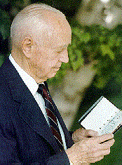 Obviously, no one person can claim all the credit; it was andcontinues to be a collective effort. Still, a few names standout and among them, one stands foremost: Captain Elrey Borge Jeppesen,who died in late November at the age of 89. (This interview firstappeared in the March 1992 issue of IFR.)
Captain Jepp is instantly recognizable as the founder of Jeppesen& Co. but even among pilots, he is less well known for hispioneering work in inventing the actual procedures his chartsdepict. As did many of his generation, Jepp became hooked on flyingat a young age, after paying $5 for a ride in Jenny in 1921. Hebought his first airplane — a $500 Jenny — in 1927 and wentbarnstorming through the western states. When his travels tookhim to Dallas, Jepp took a job with Fairchild, doing aerial surveywork in Louisiana and eventually in Mexico. Later, he signed onwith a Portland airmail operator for his first tour as a mailpilot. He was never sure if his Fairchild experience piqued hisinterest in chartmaking but by 1930, Jepp had begun to compiledetailed notes on the airmail routes he was flying, includingfixes along the way and airport diagrams. These notes becamethe basis for his famous "little black book" and representedthe prototypes for what have become modern instrument approaches.
 Jepp and his wife, Nadine, operated the growing chart businessfrom various basements around the country, while Jepp continuedhis flying career with United Air Lines, the successor to BoeingAir Transport, an early mail and passenger line.
Jeppesen & Co. established itself (and it remains)the dominant commercial maker of aeronautical charts. Jepp flewthe line with United until 1954 and ran the business full timeuntil 1961, when he sold the company to Times Mirror Co.
Jepp and Nadine settled in the Denver suburb of Englewood,Colorado. On December 17th, 1991 — First Flight Day, appropriatelyenough — Captain Jepp graciously invited us for a visit. We spenta fascinating afternoon in his office discussing the early daysof instrument flying.
By the late 1920s, you’d done quite a bit of barnstorming andflown with Tex Rankin’s Flying Circus out of Portland and thatled to a job doing aerial photography for Fairchild. How did youstart flying the mail?
Well, after Fairchild, I’d flown for Varney out of Portland. Thatwas in April 1930. After that, I went with Boeing Air Transportbut I didn’t fly much. They hadn’t any work in those days, justno openings. There was only one or two airplanes going everydaybetween Oakland and Chicago and that was the trans-continentalin those days. That was all single-engine airplanes, the Boeing40-Bs. And they had an experimental Tri-Motor Boeing they wereplaying with.When the Depression came along, I went back withFairchild up in St. Paul, flying a run over to Duluth and EauClaire. Fairchild wanted me to go back to New York and I saidno, I’m going to Cheyenne and try to get my airmail job back.And I got hired on.
With the airmail contracts, there must have been a lot of pressureto fly, no matter what the weather.
Well, there was. You didn’t have very much in the way of weatherreporting. They had a few farmers around some of the towns andthey’d spot for us and maybe call the sheriff’s department witha report. I remember up near Laramie, they stationed a crewabout 50 or 60 miles north of the airport to catch cold frontscoming down into Cheyenne. That worked pretty well. Most of time, we didn’t know what to expect.
Whether to go or not was pretty much up to the pilot. If you didn’tget the mail through, you might get canned. If you got it throughin conditions that were a little too hard, why, you might getyourself knocked off. I know back in the early days, some of thepost office people used to say we had to fly, no matter what.One of the pilots, Ham Lee, wouldn’t go, so they fired him. Theypicked the next pilot and told him to go and the fellow said ifHam won’t go, I’m not gonna go. I guess if we hadn’t straightenedit out, they’d have fired us all.
At that time — about 1930 — there weren’t any navaids, otherthan the lighted airway beacons. Were you able to fly the 40-Bon instruments?
I did a little of it. But I’d say 80 percent of the pilots didn’tfly any instruments at all. You weren’t really equipped to flyinstruments. The 40-B had a turn and bank, a compass and an altimeterand that’s about it. At first, there was no electrical system. The gyro (turn and bank) was a vacuum-driven deal with thatthing sticking out the side of the airplane. It would ice upand wouldn’t do you a damn bit of good.
Then you’d get a little ice on the wings and those wires wouldstart to vibrate and they’d pop just like a rifle. It kind ofshook you up a little bit. The Tri-Motor Boeing was a little better.It had a horizon in it but you couldn’t rely on it.
You couldn’t use it for a straight-ahead climb. You’d bring thenose up and this thing would only hold the pitch for three orfour minutes and then it would sink down. Can you imagine tryingto fly instruments with something like that?
Flying in IMC was possible. But there must have been no wayto navigate, other than dead reckoning?
That’s about right. Sometimes you could get on top of a low overcastor a fogged-in condition and fly over that. If you got stuck ontop, you’d better find a hole or find someplace you could letdown.
Down in Mexico, with Fairchild, I used to fly on instruments betweenMexico City and Tampico. I didn’t have to worry about the letdownbecause I had the whole Gulf to shoot at. I’d just fly over theinland until I was pretty certain I was over the flat area orthe water. If I was over the water, I’d come back and run a landfall,then up the coast to Tampico.
How about the Rockies, where you did most of your flying? Itmust have been doubly difficult to navigate near high terrain.
Actually, I think weather flying was a little easier over themountains than it was over there in Cleveland or New York. Outhere, you’ve got all the mountains and valleys and you could usuallyfind a place to get down. Over there, as I understand it, everythingwould get fogged in for miles. Of course, I never flew out east.
Fellows going into Portland, for instance, they’d line up withMount St. Helen’s and Mount Hood poking up through the cloudsand sort of spiral down. But you had to have pretty good ceilingsto do that.
When did you begin to realize that commercial aviation wouldhave to be built around instrument flying?
I’m not sure I ever really did realize it. You know at the timeI started, I was just a kid. These older guys had been flyingfor eight or ten years. I didn’t really think much about a systemor publishing it. I really did it just to save my own hide.
I remember making notes and trying to remember as much as I couldby getting it down in writing so I could rehearse it. Then I’dhave it some day when I really needed it. It’s hard to believenow, but back then, we didn’t have much to go on at all. You’dcome chugging along there at night…there aren’t any lights tospeak of around the airport, except for a beacon…you hoped.
The fact that I was so young helped some, I guess. One day they’dsend me in this direction and one day another. Maybe the nextday, somebody would get hurt or killed or something. That happeneda lot, you know. Well, they’d say send Jepp over there and lethim fly the route instead of sending a family man. All he’s gotis a suitcase. And that’s about right, too, that’s all I had.
Is it true that some of the veteran pilots weren’t enthusiasticabout IFR flying?
Looking back, it’s hard to believe, but a lot of pilots, a lotof the old timers never did adapt to IFR. I remember once, afterthe Tri-Motor Boeing came in, this was about 1930, the governmentdecided we had to have a radio license. So they picked us up ina Tri-Motor and we all went to San Francisco to get a radio license. We had eight or nine pilots on that Boeing, from Cheyenneand Salt Lake. We landed in Sacramento, trying to get to Reno. We would fly up the hills, down the canyons, all around, lookingfor holes. Finally, we got back on the ground in Sacramentoabout 5 o’clock.
Well, the fellows got to drinking a little and I casually mentioned that one of these days, we were going to be able to fly throughthat weather or fly up over it. Old Ray Little, God, hegot mad. He started poking me in the chest with two fingersand he says, "I know every rock, every river and every pebble on that mountain between here and Reno," he says,"and I tell you, we’ll never do that." I finally snuck away. But Ray called the chief pilot and said, "Youbetter watch that Jeppesen. He’s got some strange ideas aboutflying."
But not everyone was like that. Some of the old timers turnedout to be pretty fair instrument pilots. They went on to flythe Boeing 247 and the DC-3.
When did radio navigation become practical for IFR?
They were putting in the radio beams, the old four-legged radioranges, as early as 1930, I think. The stations were kindof spotted across the country, not really what you could callan airway system, nothing at all like you have now.
But they weren’t using them. They had no procedures for them,no charts, just nothing at all. In fact, they never even publishedthe frequencies for quite a long while. You couldn’t even findout where the legs ran. I guess the government didn’t want usfooling around with them.
But you did anyway?
Oh, yes. I used to take the chief pilot’s airplane, the 40-Bthat he checked everybody out in, and go over to work letdownprocedures. We had dug some of the frequencies out of the Department of Commerce by then. Anyway, I’d fly over to Laramie or Rock Springs and various places trying to figure out how you coulduse the ranges to get down under a ceiling of maybe 500 or 600feet. I’d do it in visual conditions, of course, and then I’dwrite it all down so I’d have it for a bad night.
I probably worked out most of the procedures between Chicagoand Oakland that way, between 1932 or 1933. Lots of other fellows,the younger ones, were trying to do the same thing. And theywould pass the information on to me.
Did you work things out on the fly or did you have some governmenttopo charts to work from?
I never did see any government charts in those days. We didn’thave much of anything, really. Rand McNally wasn’t making aeronauticalcharts. Guys going cross country kind of felt their way alongthe highways or maybe a river or railroad. You were really onyour own.
So for the letdowns, I’d do most of it visually. I’d go out andfly a five or ten mile circle and take a look. Then I’d figurethat the logical way to do it was to come in on this beam or thatbeam, get the cone of silence and then turn ten degrees this wayor thirty that way. Then I’d figure 30 seconds later or a minute,you’d have to pull up if you didn’t see the airport.
How about elevations and distances and all the other technicaldetail that goes into plates and charts?
Even then, the survey information wasn’t very good. You’d be surprised.There was one peak out east of Salt Lake, they had no elevationon it. It’sabout 9200 feet, but they had no elevation.
Later on, during the war, when the Japanese were moving into theAleutian Islands, they locked us updown here in the bank buildingand had us make instrument charts for Alaska. Some of those mountainshad seven elevations for the same one and they’d vary two orthree thousand feet. I’d just take the highest one and put aplus or minus on it, which meant the elevation was uncertain.
The best information I got was from the engineering departmentat the Union Pacific in Omaha. But a lot of it, why, I’d justgo out and get myself. I’d maybe drive or fly out there and tryto get an elevation at the base and an estimate for the top.Some of them I climbed up with an altimeter, which seemedlike a pretty antiquated way of doing it, but it was all I had.I’d get a lot from pilots, too. I used to send these things out[a form with courses, elevations, distances, etc.]. The pilotcould sketch in the information then we’d have to go back andsurvey it.
What sort of minimums did you have on those early approachesand how did you determine them?
Oh, if you got a good clear signal, you could go down to 200 feet.Maybe a little lower. But we really didn’t have minimums the wayyou do now. It was really up to the pilot. The procedures weren’tstandard then.
You mean everyone would fly an approach differently?
Yes, that’s right. You see, in 1930 and 1931, we had no air trafficcontrol of any kind. We did have radios so we could call downto the dispatcher andtell him where we were and maybe that we were starting our procedureat Salt Lake, but that was it.
In fact, that’s an interesting point. When I first started sellingthe Airway Manual, every airline had their own procedures. United,Western, American, and so on. I’d go down and see the chief pilotand he’d say "Jepp, what can you do for me?" And I’d explain the Airway Manual. Then he’d say something like"Well, if I want to change the altitude of this procedureturn or some such, I can just call in the office girl there andhave her do it and make a bunch of mimeograph copies for thepilots."
So what I did was to set up a tailored service and a standardservice. I could see that it was going to become standard someday, with all of the traffic we were getting. But when I cameto sell you a manual, I’d tailor it just the way you wanted it.Before long, the letdowns were standard and I didn’t have todo as much tailoring.
Your early manuals show approaches built on the low-frequencyranges. What was it like to fly them?
We did pretty well with it but at the time it was kind of an uncertainthing. You’d listen for an A on one side of the course and N onthe other, then a more or less constant tone between.
Pretty soon, it’d just fade out for a little while and you’d pickit up on the other side and you’d know you had gone overthe station, through the cone of silence. Lots of times, though, you couldn’t hear much because of snow static and so forth.Ice, too.
One night I lost most of my antennas down there in the LaramieValley. They iced up and broke off. I didn’t hear anything atall until all the way past Elko. I just climbed up to 14,000 feet.I came out three or four miles north of the airway, past Elko.By then, the clouds were breaking up and I could just start topick up the lights.
Even in the DC-3, we still had to dead reckon. For instance, you’dcome out of Cheyenne and you’d cross this beam and you’d takeyour time and when you’d cross the next beam, it’d give you someidea of the kind of wind you were bucking, headwind or tailwind.
There was no other way to tell how far out on the range leg youwere and that could get confusing. I remember the east leg ofthe Salt Lake range, you’d fly north and south across it and get20 or 25 on-course signals because the thing would bounce aroundbetween those peaks.
Even when you knew where you were on the approach, it wasn’t easy.You had to be careful around those mountains.
The manager there at Salt Lake had a phone put in at the far cornerof the field to get way from all the noise, then he’d listen foryou and give you a position report. "Yeah, I hear you, Jepp,over to the northwest, blurp your engine." At least thenyou knew you were past the mountains so you’d go back to the rangestation and work a letdown.
At the time, were you the only one making charts or were thereothers, too?
Oh, there must have been seven or eight fellows trying to getinto the business. They never really got anywhere with it. I’vegot one of them around here somewhere by a fellow who was a dispatcherat Braniff. He was under a handicap, because he was doing itfrom the ground. I was doing it from the cockpit.
I never could understand why none of the big companies like RandMcNally got into it. I guess they were making so much money inthe road map business they couldn’t see aviation coming.
I know I was told that every time Rand McNally checked up on me,they thought I was going broke. I guess I had them fooled. Ithink they thought the government was going to take it over.The government eventually did start making charts but not untilabout 1938, I think.
Your first published charts were in these small binders, aboutthe size of the original black book?
Yes. I had been talking to United Airlines and they wanted themanuals so I printed up 50 procedures and letthem have those.I just kept enlarging it from there. I had the whole United Statescharted like this when the war broke out. Eventually…must havebeen before the war, we went to the larger size plates that youhave now. Fred Kelly at Western wanted the thing in the smallsize so it would fit in a coat pocket. He paid the printing bill.But they were too small to read so we went back to the largersize.
When Nadine and I got married in 1936, we ran the chart businessout of the basement at Salt Lake. At that time, getting the chartsout on time wasn’t easy. I’d go see a printer and he’d say "Well,I can get that out in ten days." Of course, I needed it intwo hours.
I didn’t know anything about printing but I learned quick. Learnedabout paper, too. Grain, crackle, burst, that sort of thing. Overthe years, we’ve done a lot of things that you wouldn’t thinkwould make a difference.
During the war, I had to go see Forrestal (Secretary of the Navy)to get a barrel of titanium so the paper would be opaque enoughto print on both sides without showing through.
Look at this binder, with seven rings. It had to have seven becausethe paper’s so light it would rip too easy with fewer rings. Thenwe put the lockbooster on the rings so the binder wouldn’t open up and spilleverything all over the cockpit. Then we figured out that puttinground corners on the plates would keep them from getting dog-earedafter a month or two. Littlethings like that really made a difference, I think.
Looking back on those early procedures and plates, would youhave changed anything if you had all to do over again?
I’ve wondered about that a lot. If you just woke up and you’dnever seen nor heard of an airway system, what would the chartslook like? The one I built had the frequency at the top, withthe letdown in the middle, and the pull-up down here, then theminimums below that. It hasn’t changed in 50-some years. I thinkit worked out pretty good.
