GPS Spoofing Raises Alarms

25

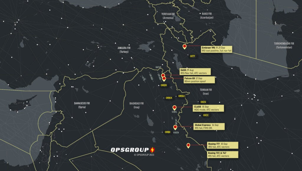
Someone in the Middle East has figured out how to spoof GPS data and it’s playing havoc with aircraft navigation. OPSGROUP, a site used by airline, business and cargo pilots, is reporting that aircraft using Airway UMB688 in northern Iraq are experiencing complete navigation system failures because the hacker replaces the position data beamed by the GPS signals with false coordinates. “[Twelve] separate reports have been now received by OPSGROUP, and in most cases the [Inertial Reference System] becomes unusable, VOR/DME sensor inputs fail, the aircraft UTC clock fails, and the crew have been forced to request vectors from ATC to navigate,” the site reported.

OPSGROUP says all of the aircraft involved have state-of-the-art navigation systems and include a range of Boeing, Gulfstream, Dassault and Bombardier aircraft. The publication stressed that this is not ordinary GPS jamming, which is a common occurrence in the area. The attacks have all been the same so far. The specific GPS receiver on a single aircraft is sent a signal that shifts the displayed position by 60 nautical miles. The aircraft’s nav systems freak out at the sudden change in data and in almost all cases the screens become useless. Crews then have to call ATC for vectors to stay on course. The publication says the loss of precise navigation data is especially dangerous in that area because of military action and the proximity of Iranian airspace, entry to which will likely prompt a military intercept.

Russ Niles
Russ Niles is Editor-in-Chief of AVweb. He has been a pilot for 30 years and joined AVweb 22 years ago. He and his wife Marni live in southern British Columbia where they also operate a small winery.

Other AVwebflash Articles

25 COMMENTS

  1. I think the headline is misleading, the article describes something much more significant than GPS spoofing.

    • Most of the aircraft involved have IRS systems. The GPS signal regularly updates the IRS in the FMS. The spoofing then corrupts the position of the IRS. We had a failed #2 GPS in our Global recently, and it took out the 3rd IRS with it.

  2. I guess I don’t get it. Aren’t there still terrestrial navigation VOR/VORTAC stations that can be used for CDI and DME? And doesn’t the FAA require a whiskey compass even when there are remote magnetometers onboard? Most STCs I have seen for magnetometers also require a whiskey compass visible to the pilot. Surely the designers of modern digital flight decks didn’t design the systems, including terrestrial nav, to be 100% dependent on satellites? If they don’t like the satellite signals they turn off all navigation options? Seriously? If so that’s a major faux pas.

  3. How can spoofing a GPS signal cause other, non-GPS navigation equipment — particularly IRS — to stop working? Seems like something more elaborate is going on here.

    • My guess, is that the IRS uses GPS as a cross check and to update for drift. While a slow drift of a few hundred feet or so is “correctable”, a sudden, 60 mile delta confuses the system.

  4. Over the years I have experienced slight GPS issues, but nothing like that. Had the nose of the aircraft pointing right towards the airport, 5 miles out, and it said I was 15 miles out and 10 degrees off course. Another time it locked up and kept my position for 20? miles and didn’t update. Then magically righted itself. Different aircraft, different GPS units. Basically I reverted back to my earlier training. Trust but verify.

  5. Both ADS-B and GPS are unencrypted and unauthenticated. Building an airspace system with no security and open code means that anyone with ill intent can “play” with it.

    • GPS signals are encrypted. In fact there are several signals transmitted simultaneously. All of this is in the public domain and you can read about it anywhere––Wikipedia has an excellent discussion of the whole system. Military operators use codes that have encryption and anti-spoofing capabilities that are not available to civilian (and most likely contractors) users. The biggest mistake (IMHO) is using GPS (only) to guide rocket artillery systems, drones, and cruise missiles. A powerful jamming signal can disrupt even an encrypted code, but that jamming signal can’t be transmitted continuously in combat because it’s a very simple matter then to destroy the jamming transmitter. Cat and mouse; learn on the fly and adjust; just like war has been waged for thousands of years.

      • Couple things: First, jammers doesn’t always need to particularly “powerful” to work; it depends on where they are and what you want to achieve with them. Second, encryption doesn’t really make it harder to jam, it makes it harder to spoof. Third, you might want to ask the folks on the front in Ukraine how easy it can be to find and eliminate one of those jammers in a highly contested environment. It’s not as easy as one might assume. Oh, and your comment is why all those weapons often work much like the airliners: GPS initializes an INS before launch and may be used for cross-check and corrections to the INS in flight.

  6. If they can divert aircraft into Russian airspace, they now have a supply of spare parts they badly need.

  7. I was criticized for leaving both my ADF and my antique King KX-155 in the airplane when I upgraded to Dynon Glass with GPS. My reasoning: redundancy in case GPS fails. I stand by my decision (and fly by it).

    • Thats what I thought right away, John. I can see the GPS providing cross-reference info to other systems to ensure they’re all ‘humming’ together but if an airplane has an inertial nav system, there ought to be a way to tell it that the GPS input is inop and to continue on its own vs getting stupid.

      Over 50 years ago, I was trained to maintain the B-58 “Hustler” INS and IT could find its way to the bad boy’s location and take care of business without GPS. Sounds to me like someone didn’t design these systems correctly and this issue highlights same. Just put another hardwire switch or software way to turn off the GPS requirement. IF the INS can’t work on its own … it’s no damn good anyways.

  8. So I’m reminded of the “UFO/USP” phenomenon off the coast of San Diego.
    What if if it becomes possible to shift displayed locations more subtly where the Nav doesn’t get ‘confused’ and a less than crackerjack crew doesn’t pick up on the anomaly? International incident?

    • Its called Meaconing. It was done pre GPS. The Soviets allegedly used meaconing to lure USAF aircraft into their airspace so they could then shoot them down. Also allegedly, this was done to KAL flight 007.

      And while we are on UFO’s, there’s a theory that a similar phenomenon exists in the Bermuda Triangle. Now, all we need is to somehow get the pyramids involved, lol.

  9. I’m pretty sure the systems on the jets they are talking about are much more sophisticated than our usual general aviation gps systems. I believe the modern inertial reference systems in commercial jets also cross reference gps, and perhaps the programming of the newer systems in these particular jets, did not allow for such a huge deviation and to take the erroneous signal out of the equation, with a notice to the pilot. I think modern IRS systems would be a great subject for Paul to tackle 😀. I’m sure right now the manufacturers are looking at their software and procedures to try and bulletproof the system. Just my semi-educated opinion.

  10. Sounds like there’s a potential software fix that would decouple INS from the GPS cross check, revert to INS position if the GPS jumps. that won’t happen overnight but it ought too be possible as a countermeasure.

  11. Fascinating. This thread brings to mind all the Walmart and Amazon delivery drones. You know, the ones with the “foolproof” autopilots and navigation, and _no_ pilots on the ground for when something goes wrong?

    But 50lbs @ 50 mph ain’t going to hurt someone on the ground. Right?

  12. When LORAN was being phased out, I somehow got on an email list to try to keep it active as a backup. This issue highlights that should have been done.

    Now that the Ukrainians have EXCALIBRE systems, you can bet the Russians are taking note of all of this and working to either spoof the GPS or overwhelm its signal.

  13. Most sophisticated modern navigation systems, the IRS’s ( gyro’s) feed their information into the FMC ( computer) and that’s where the corrections are made using the GPS’s, VOR’s, DME’s etc. for navigation displays.

LEAVE A REPLY