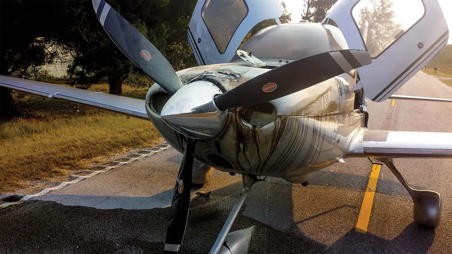
Prepare For The Unthinkable
Just because the chances of dealing with a forced landing are relatively slim doesn’t mean we shouldn’t plan for one—on every flight, and especially on every takeoff. Flying in IMC…

The key to any off-airport landing is to touchdown at the slowest controllable
airspeed, and fly the plane until it stops moving.
Just because the chances of dealing with a forced landing are relatively slim doesn’t mean we shouldn’t plan for one—on every flight, and especially on every takeoff.
Flying in IMC poses an even greater risk for the complacent because there’s less time to assess what lies below. Knowing the immediate steps to take by memory on an engine failure is critical. There may be little time to refer to a checklist.
Know The V-Speeds
Of all the airspeeds you should commit to memory is the best glide speed for your aircraft. Be aware that this is based on max gross weight and standard conditions. Since you’re rarely at max gross weight except maybe at engine start, a general rule of thumb is to reduce glide speed five-percent for each 10-percent below max gross weight.
Winds can significantly affect your gliding distance and are more difficult to compensate for during an engine out. First, you need to know the wind direction and speed. Your GPS may provide this. A typical rule of thumb is to increase glide speed by half the headwind component or decrease glide speed by a fourth of the tailwind component to achieve the maximum range.
Positional Awareness
On breaking out of the clouds during an emergency descent, we may only have seconds to react. To improve the odds, you should have a sectional either displayed electronically or close at hand during flight—and refer to it frequently. A sectional is the best source of information into what you’ll be descending.
En route, about every 15 minutes, assess your actions if a forced landing should become a reality. This minimizes time and altitude lost, determining where to go.
What About An Airport?
Take advantage of the Nearest button on the GPS to “see” what airports are nearby before you need them. Note that depending on how the GPS is configured, it may not show every available airport, such as private fields or small grass strips. It’s unlikely ATC would be aware of potential small fields that may be close by. This is where the sectional becomes essential.
A word of caution—even if an airport is shown on a sectional, it may not be active or maintained. You might be looking at an old crop duster strip in the middle of nowhere. One landing strip on my sectional had a building erected at the end of the rather short runway. At night time you might never be able to find some of the smaller fields, especially if unlit. On a VFR day, a great exercise is to try and find small private airports. You’ll see how difficult it is to locate some of them even in optimal conditions.
Hostile Terrain
Naturally, we all route-plan to avoid weather. But what about route planning to avoid hostile terrain, especially at night? A new airplane owner recently opted to fly the plane out over the Gulf of Mexico. Just before reaching the opposite coast engine problems developed. The engine quit as they crossed the coastline, but by luck, an airport was directly below. They are fortunate since they had no survival gear onboard had the engine decided to quit sooner.
Fuel
Flying in IMC, we tend to lose a sense of time and distance. Fuel starvation has been the source of many a forced landing. Having a useful flight log prepared with anticipated fuel burn at various points along the route of flight and notations of when to switch tanks can help ensure against running a tank dry or fuel exhaustion. You can’t always rely on the older fuel gauges as they are notorious for being inaccurate except when they read empty.
Fuel totalizers, when programmed correctly, are generally a more accurate way to keep track of the amount of fuel that is being burned. If you have multiple tanks, it might be wise to keep one in reserve. My plane has four tanks. I always keep one full and in reserve so I know exactly how much fuel is available in at least that one tank.
A too frequent cause of fuel starvation is inadequate venting of the tank. Do you know where your vents are located? Is it possible for them to get obstructed? I put a protective screen over the vents since a variety of bugs seem to find them a great place to build a nest.
Some vents are in the fuel caps. Ensure your fuel caps are secured before the flight. After refueling by an FBO, make sure they put the right ones back on and correctly.
Survival Gear
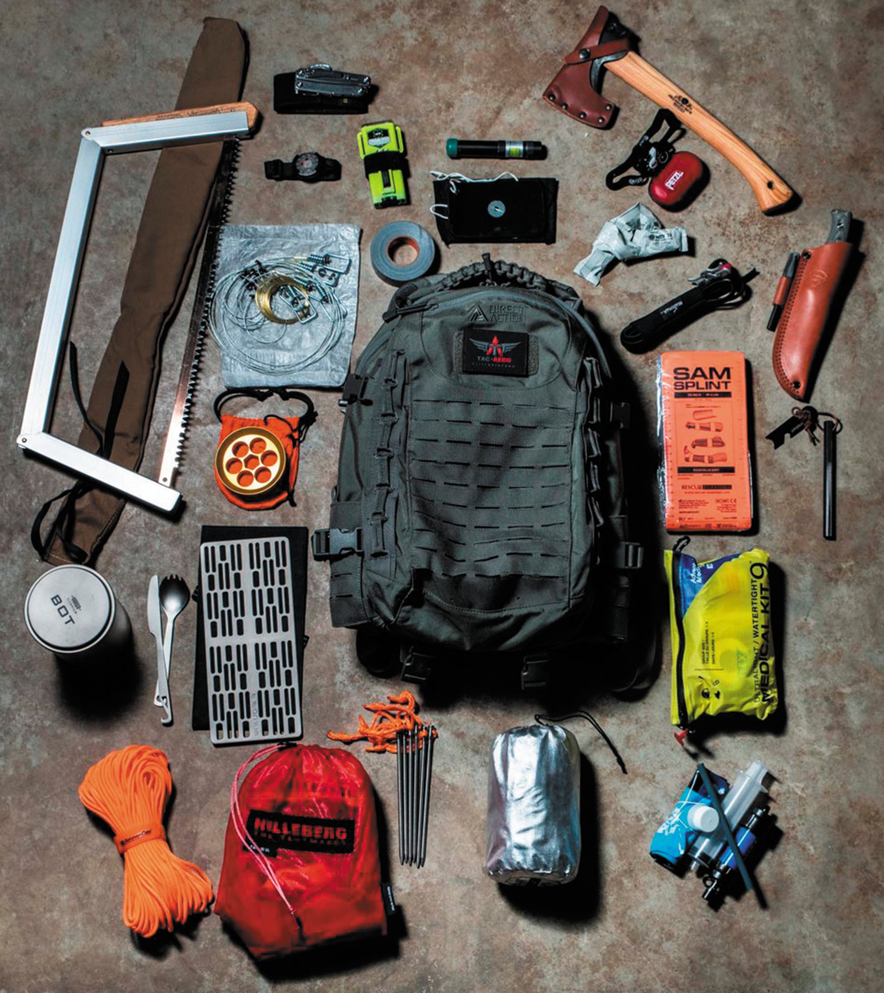
Always carry a survival kit on board for every flight. However, one size does not fit all. The survival kit should be tailored for the route and conditions of your flight. While there are essential items that should be in all such kits, there are others that are more germane for the particular flight, such as life vests or rafts for extended over water flights or a portable saw for over forested areas.
You can get carried away with what items to bring along, though it is better to over than under prepare.
One item I recently came across that I think is a vital addition to any survival kit is a solar charger for a phone. Your phone is your lifeline in a crash. Cell phones can be used to triangulate the position of a person. Not only does it provide communications capabilities, but it can help you navigate to more hospitable terrain if necessary or even civilization. It also has a light as a backup for a flashlight.
We have all become dependent on cell phones, but they are only useful if you have cell coverage. In remote areas, the phone may be useless for communications . However, it can still be a valuable tool for navigating to nearby civilizations. I recently heard of an aircraft that went down in the Florida swamp. The survivors proceeded on foot in the wrong direction, taking them deeper into the quagmire. Had they looked at their phone, they would have discovered there was a road nearby.
Dust Off That Handheld
Because of cellphone limitations, that handheld radio may be a vital survival tool. Airlines monitor 121.5, and chances are no matter where you are, there is an airliner flying overhead within range. Additionally, search and rescue teams will most likely be monitoring 121.5.
Best advice on surviving after the crash is to stick with the airplane. ADS-B can provide a tremendous boost to search and rescue teams in locating a downed aircraft.
Familiarize yourself with the ELT. If you decide to leave the vicinity of the crash site, then bring the ELT with you, so they find you and not just the wreckage.
One last thing. Most FBOs provide pilots with a bottle of water. Please take it. I always ask for a bottle of water before I depart. Dehydration can begin to affect your reasoning ability in as little at eight hours. Unless you are forced down in an urban area, it could be hours before rescue personnel can be mobilized and get to you. My FBO also offers a free cookie as a bonus. On every flight, expect the unexpected and have a plan already in mind to deal with it.
Richard Lanning Ph.D. is a graduate of the U.S. Naval Academy and a pilot for more than 30 years. He is an ATP and CFII and is a gyroplane CFI.
This article originally appeared in the March 2020 issue of IFR Refresher magazine.
For more great content like this, subscribe to IFR Refresher!