In 22 facilities across the U.S., thousands of air traffic controllers actively watch the skies over their assigned sectors. Each Air Route Traffic Control Center (ARTCC) is almost a small town in itself. The Operations Room contains 50 to 60 consoles with large computer monitors displaying aircraft data blocks imposed on top of aviation landmarks and sector boundaries. Surrounding the control floor are administrative, training and technical staff offices.
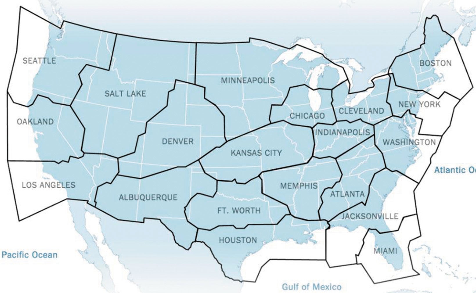
Each ARTCC has a unique facility ID beginning with the letter Z. Most are pretty obvious, ZAB-Albuquerque, ZDV for Denver. Others are recognizable if you are familiar with the suburb of a larger area in which they exist—ZOB is for Oberlin, Ohio outside of Cleveland, but it’s called Cleveland Center.
The Boundaries
Center boundaries are oddly shaped, partially because they were not created at once. A consortium of commercial airlines and airport operators established the first three Centers (Cleveland, Chicago and Newark) between 1935 and 1936. The Bureau of Air Commerce, within the Department of Commerce (DOC), took over their operation when it assumed responsibility for what was eventually known as “air traffic control” or ATC in July of 1936. As air traffic density moved west, new Centers were created to manage the flow and were initially built around densely populated areas.
The geographical area covered by each ARTCC spans several states and is divided into sectors both geographically and by altitude. For example, in areas of dense traffic one geographical area may have different sectors controlling aircraft below 18,000 feet MSL, another for altitudes between 18 and 28,000 feet, and a third for aircraft 29,000 thru 60,000 feet.
Sectors are adjusted according to the traffic they serve. In the west, Albuquerque Center has one sector where the controller works aircraft from the surface to 60,000 feet MSL. This is a special case where Restricted airspace precludes most air carrier traffic.
Area And Sector Operations

Within each ARTCC are defined geographical Areas, each of which contains about six to nine sectors. Controllers are trained to operate all the sectors in their Area. For instance, in Albuquerque ARTCC the Southwest Area covers all southern Arizona—Phoenix Approach and a host of small airports as well as the southern ADIZ. Fully qualified controllers in this Area are seated close together and must keep aware of what is happening at all the sectors around them. Part of the job is developing an awareness of peripheral activity, which may impact your sector. Each sector in the ARTCC airspace is monitored by one to three people during the day. The practice of airlines to land their fleets together as close as possible to enhance route connectivity causes air traffic to increase and decrease in waves. At the busiest times each sector may have three controllers watching.
The R-Side, or Radar controller is talking to the pilots and issuing clearances—the primary person controlling the sector. During most daylight hours there will always be a second person assigned to each sector whose function is principally communications and computer input. While the Radar controller is talking to the aircraft, the D-Side (Data) controller is coordinating with all the surrounding sectors and facilities. For instance, an aircraft requests descent to another altitude. If the aircraft is already close to the border of the sector’s airspace, the D-Side will call and APREQ (request approval) from the next sector prior to the Radar controller issuing the descent instruction to the aircraft.
The D-Side controller monitors the flight strip information on all the aircraft currently on the sector’s radar as well as the strips for aircraft 30 minutes away. Early knowledge of how many aircraft and what pathways they are flying provide the sector controllers opportunity to mitigate problems before they arise. If the D-Side sees a potential conflict, she can reach out to one or both of the other sectors and request assistance in changing the aircraft’s heading or altitude to ensure separation.
Really busy sectors and times of day may necessitate a third controller who stands behind the other two providing another set of eyes. This person makes coordination calls as needed.
In addition to actively controlling the aircraft, controllers take PIREPS about flight conditions and weather reports and pass them to their Flight Data Assistants to be entered into the national weather service database.
The Flight Data Assistants ensure information coming into the ARTCC is complete and accurate before it’s posted to the sectors. They coordinate non-control information with other air traffic facilities, such as parachute jumping activity to assure the appropriate sectors are aware of when and where this will take place.
During times of light traffic— such as during midnight shifts— one person may handle all the duties for several combined sectors.
GENOTs/RENOTs or “General/ Regional Notices” come into the Flight Data computers along with Temporary Flight Restrictions and other operationally significant information. The Flight Data assistants determine which sectors or staff could be affected by the information and distribute it accordingly.
Besides general administration, ARTCC support staff includes a military liaison, and a National Weather Service group who focuses on how weather will affect the traffic in that Center’s airspace and issue appropriate Center Weather Advisories.
Each ARTCC has personnel assigned to the Air Traffic Flow Management team. Flow Control monitors the activity in and around the entire ARTCC airspace, along with weather patterns. They also track flight planned proposal times of aircraft wanting to join the dance aloft. If projected volume exceeds established parameters, or if weather causes difficulties in certain areas, the Flow controllers initiate departure or arrival delays.
Transferring Control
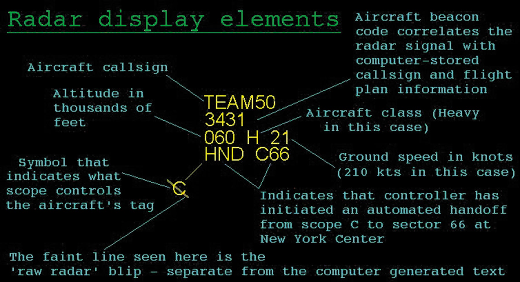
Thirty minutes prior to takeoff, or (if airborne) the time it’s expected to cross into a different ATC facility’s airspace, its flight plan data is transmitted to the receiving facility. The aircraft show up as small arrow like icons with data blocks appended. Controllers can extend a line forward along the route of the aircraft to see if it will conflict with other aircraft. The data blocks contain the aircraft’s Identification, Altitude, Speed, and the aircraft’s computer-generated ID.
Data blocks flash whenever the aircraft approaches the boundary of the sector’s airspace. Simultaneously, the flashing block will appear on the next sector’s or TRACON’s radar with the ID of the next sector flashing in place of the computer ID.
As the aircraft approaches the invisible boundary of Approach airspace, the computer screen starts flashing its data block on the display to alert the controller. Simultaneously the equipment at the sector receiving the aircraft will pick up the signal and flash to alert that controller of an incoming aircraft. If no further coordination is required, the incoming sector controller keys the accept key and the outgoing sector controller instructs the pilot to change frequencies.
If the sector controller sees a problem with the aircraft approaching his airspace he calls the controller currently handling the aircraft to have it put on an alternate heading or altitude before it enters his airspace. Only after this change is made will the incoming controller accept the handoff.
For instance, an air carrier departs Amarillo, TX in Albuquerque ARTCC’s airspace eastbound. The Fort Worth ARTCC boundary is close, so the air carrier is normally still climbing to its requested altitude as he crosses it. Fort Worth sees the aircraft handoff, but has traffic at FL260. The Fort Worth ARTCC controller calls Albuquerque ARTCC and asks that the air carrier be stopped at FL250. Once Fort Worth sees the altitude information in the data block has been changed to reflect the new clearance altitude, they accept the handoff. Fort Worth will allow the air carrier to continue the climb once the conflicting aircraft is no longer a factor.
Similarly, when handing the aircraft off to an approach control, the data block will flash H (for handoff) plus the ID for that facility. When ZAB Sector 20 hands aircraft off to ELP TRACON, the data block flashes H-ELP until the Approach controller accepts it.
The further ahead an action can be taken to avoid aircraft coming into conflict, the easier it is on the pilots. For instance, if the computer shows a potential conflict 200 miles from the conflict point, one or both aircraft may be asked to alter their heading by only five degrees, then be set on course once the required separation is achieved.
Each computer screen in the facility can show just one sector or be expanded to include the surrounding sectors as well. This comes in handy for midnight shifts when sectors are combined or during emergencies such as when Chicago ARTCC was shut down after an intruder started a fire in the facility. In that case, the sectors from Indianapolis, Minneapolis and Kansas City ARTCCs, which abutted Chicago ARTCC, expanded their computer screens to cover Chicago’s airspace.
The computer screens have toggle on/off switches to display the airways and fixes in the area as well as significant weather patterns. Air Traffic radar is normally set to minimize weather displays unless there are major systems transiting the area. Separate monitors in each grouping of sectors are set to display weather continuously.
Next Generation — NEXGEN
The ERAM, or En Route Automation Modernization system developed by Lockheed Martin is the latest computer system implemented in all U.S. ARTCCs. ERAM gathers and interprets information from both radar and satellite returns and extends coverage beyond any single ARTCC facility’s boundaries. ERAM has increased the ability of controllers to route aircraft around congested airspace, and weather safely.
This Next Generation technology has the capability to determine how closely an aircraft is following its flight plan, which will improve the efficiency of the ATC system. To do this, the system needs to know the sophistication level of each aircraft and the capabilities of the pilots using it. Conventional domestic flight plans do not have the extra fields that communicate this data to the ERAM, hence the use of the ICAO (International Civil Aviation Organization) flight plan. The equipment portion of the ICAO flight plan, plus the data entered in the “other information” field, identify the technological abilities of both the aircraft and the pilot.
The current aircraft separation rules require at least five miles laterally at the same altitude or 1000 feet vertically. If aircraft at the same altitude look to be converging, the computer will generate a five-mile ring around those targets affected alerting the controllers to a possible situation. In Air Traffic parlance, a “near miss” means the aircraft came within that five-mile ring.
With the transition from a radar-based monitoring system to one that combines radar, satellite returns and ADS-B Out, new procedures will allow aircraft to be run closer together. The equipment is in place, the procedures defined, and the controllers have received training. The NextGen concept is on time for implementation in 2020.
Rose Marie Kern worked in all three divisions of ATC. She is a FAAST team representative and member of several pilot organizations. Her latest book “Stress is Relative” follows her career and the changes she faced in this challenging field since 1983.
This article originally appeared in the July 2019 issue of IFR Refresher magazine.
For more great content like this, subscribe to IFR Refresher!
