


Personal aviation opens up a world of interesting and beautiful places to visit and recreate, places that reward us for the time, training and skill to get there. Some places would be inaccessible except by horse, foot or airstrip, like the canyons, rivers and vistas of the Mountain West. Some places beckon because they offer a challenge or have a unique characteristic that makes arrival its own reward, like Furnace Creek airport in California and Lake County Airport in Colorado. These represent the lowest and highest elevation airports in the U.S. for those seeking a bucket-list experience.
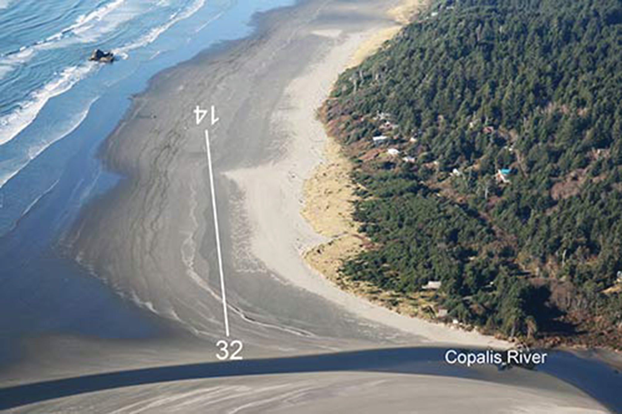
And then there are those special places to visit with your plane that are absolutely unique. Any landing spot that requires consulting a tide chart to see if the runway exists meets the test. One such “runway” is the Copalis State Airport (S16), on the Washington coast, which exists only once or twice a day, depending on the tide, not unlike the mythical Scottish town of Brigadoon. Ongoing erosion from the nearby Copalis River has already reduced the runway’s estimated 4500-foot length by some 1000 feet, so it is possible that one day the entire airport might cease to exist. For now, at least, you have a chance.
What Could Go Wrong?
With an understanding of the tides, pilots can see when beach runways like Copalis are available, but it takes some extra research, understanding and awareness. Besides checking weather, NOTAMs and the latest runway length, you must also consult how the moon impacts ocean levels to time your trip accordingly. It’s also important to verify any local knowledge and regulations.
Weather is also definitely a major factor at Copalis; it’s one of the wettest spots in the Continental U.S. The Hoh Rain Forest records an average annual rainfall of almost 12 feet (3.6 meters). Even during summer droughts, coastal fog and marine layers frequently render the coast IMC even when the sky above the land is clear and a million. But if the desire is there, your timing is good, and the moon (tide) and stars (a clear day) align, Copalis State Airport will appear for your landing pleasure and enjoyment.
Thanks to FAR 91.103 on preflight action, the FAA expects the pilot in command to be familiar with all available information concerning that flight. For Copalis State, that means looking at the tide chart. I’m a landlubber and have no real experience with tide charts, so I consulted the Flights Above the Pacific Northwest forum. The forum’s community of pilots were generous with information. They told me to look at the nearest reporting tide stations. For Copalis, that meant Point Grenville to the north and Point Brown to the south. They also recommended tide prediction apps.
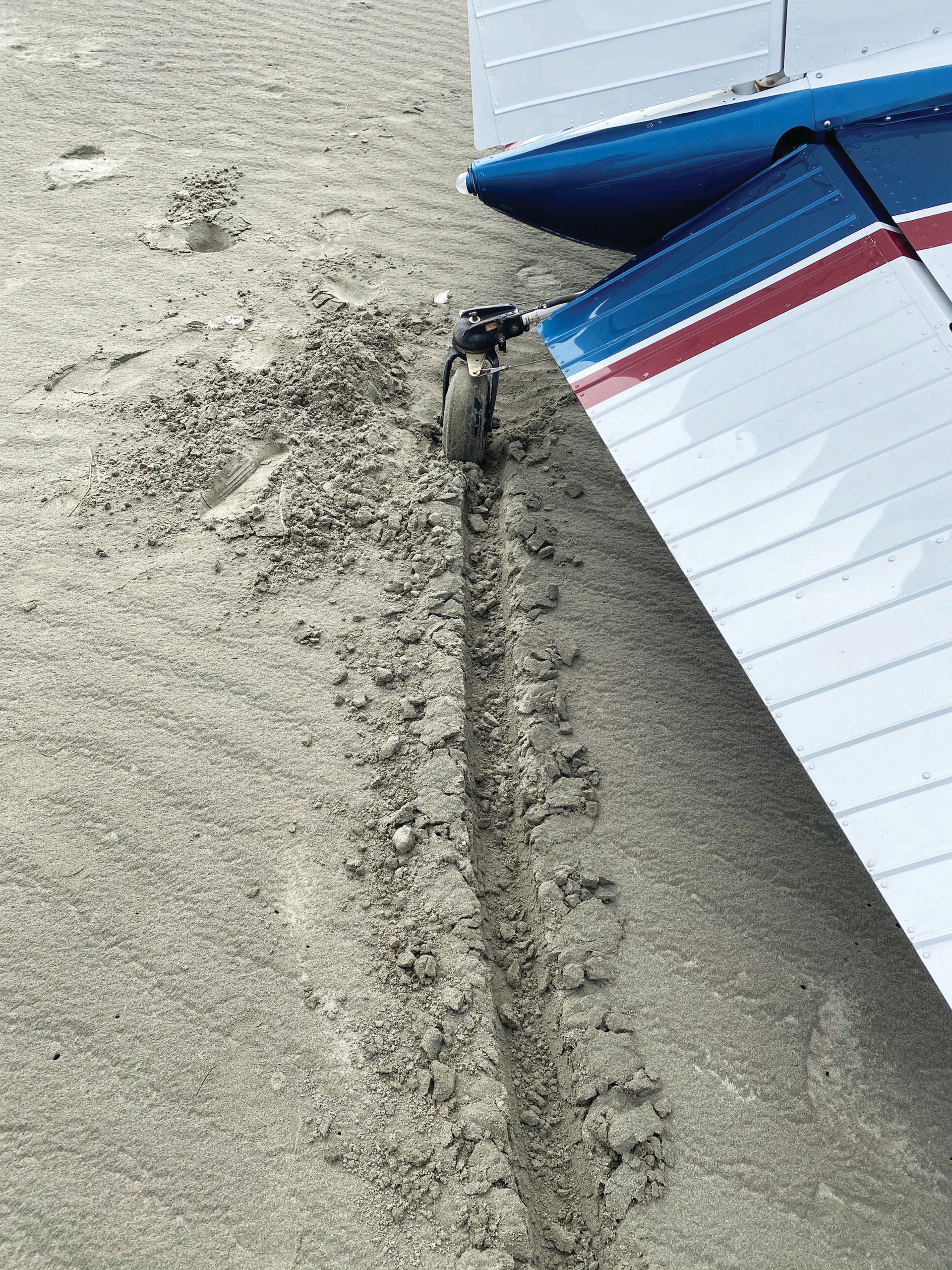
Between their input and support, the page for Copalis on the Washington DOT website, and checking out a few YouTube videos to get eyes on the runway, I started to get a pretty good idea of the risks, the major one being the landing surface itself. Land on wet sand, but don’t stop and park on wet sand, or you will sink. Park as far up the high tide area as you can safely reach, but avoid soft sand, driftwood and beachcombers. Sage advice. Further advice included: Write down the number of the local towing service, and don’t count on great cellphone coverage. Check.
More Risks Than Advertised
No one led me astray, and I never felt that I or anyone else was at risk, but there were more risks than just the runway surface. When I approached the coast where the breakers were just in view, I could see a scattered marine layer hovering at the coast line that insisted on obscuring the runway from the downwind leg. I approached the marine layer for a closer look and glimpsed a powered parachute, and then another, and yet another in the vicinity. I was not alone, but the others were Nordo.
My good weather karma continued and a nice hole opened up for my turn from downwind to base and final. I was able to spot the windsock and line up with my best estimate for the unmarked runway. I cleared the river bank and touched down to the right of some kelp. I wasn’t sure what to expect, but it was a buttery smooth surface with only a bit of extra grab.
There were no pesky parachutes or beachcombers in my path or the roll-out, but as I turned up toward the high-tide mark, the drier sand did pull on the tires in fits and starts. Following everyone’s advice, I headed up to the high-tide line as far as I could. My wheels dug into the dry sand as I pivoted into the best parking space I could muster. I didn’t sink, nor did I bury the wheels.
The beach was gorgeous, the water inviting and the scenery stunning. Hundreds of gulls danced along the water’s edge feasting on crabs, clams and other ocean invertebrates; it is at the southern edge of a marine sanctuary after all. I thought a bit about that. If someone invited me to land at a nice runway and mentioned there would be hundreds of two-pound quadcopters flying adjacent to it, I probably would have demurred. Gulls likely have slightly better ability to avoid aircraft, but between the theoretical drone convention, powered parachutes and hazy marine visibility, there definitely was some added risk I had failed to consider in my planning. But since I was already down, there wasn’t much I could do about it except be aware of the risk of ingesting or smacking a large feathered creature on departure.
Takeoffs Are Not Always Optional
One of the risk-management adages is, “All takeoffs are optional; landings are not.” A beach runway is different. At Copalis State, you’ll feel some pressure to leave—the runway, after all, has an expiration date and time. Takeoffs are practically mandatory unless you relish the thought of your trusty aerial steed spending a few hours submerged to the cowl in salt water. If you land at low tide, the clock is ticking and the water will slowly rise until at some point there will be no runway. Fortunately, the tide prediction apps show the curve nicely, and you can cross-check what is on the app versus what it looks like on the ground. You can always use a stick or piece of driftwood as a marker to see how fast the tide is advancing, and make sure you have enough time to exit.
Bowerman Field (KHQM), the nearest weather reporting to Copalis State, is also on the coast 16 nautical miles to the southwest and therefore subject to similar weather. The forecast on the day of my arrival was for the scattered marine layer to burn off and yield to clear skies at 1100 local. It didn’t really happen. While I combed and enjoyed the beach with my niece and nephew, the scattered layer I dodged to land on the beach at 1000 local time actually thickened and dropped a bit. Uncooperative weather and forecasts that prove wrong are not uncommon at any location, but that probably goes double along the coast of the wettest place in the U.S.
When I was finally ready to depart, I verified the beach was clear of powered parachutes and beachcombers, and back-taxied my earlier track. We had a mile of visibility but I could see the deep blue of clear skies lurking above the land’s edge. I made my departure call and rolled for departure. At 400 feet, I turned toward the ocean to chase another hole with improving visibility and avoid potential obstructions on the coast side. At 800 feet, I was back on top in the blazing sun above the marine layer. No gulls or powered parachutes were encountered.
A Deserving Airport
Copalis State is deserving of bucket-list status and that makes it a bit more of a risk for get-there-itis. Adding it to your logbook may require more than a few attempts to line up the optimum tide chart and weather. Remember that forecasts are not always right. If you can land, you’re committed and have set yourself up for another possible challenge, departing. Don’t be surprised if your pilgrimage to Copalis State or any similar coastal airport is dashed by the ubiquitous marine layer right at your very arrival over the airstrip. Turning around and waiting for a better day is always a good choice.
Whatever your novel destination is, do your homework and follow the FAA’s strongly worded advice to familiarize yourself with all available information. With good risk management, you will have an excellent experience and not an insurance claim.
Off The Beaten Path
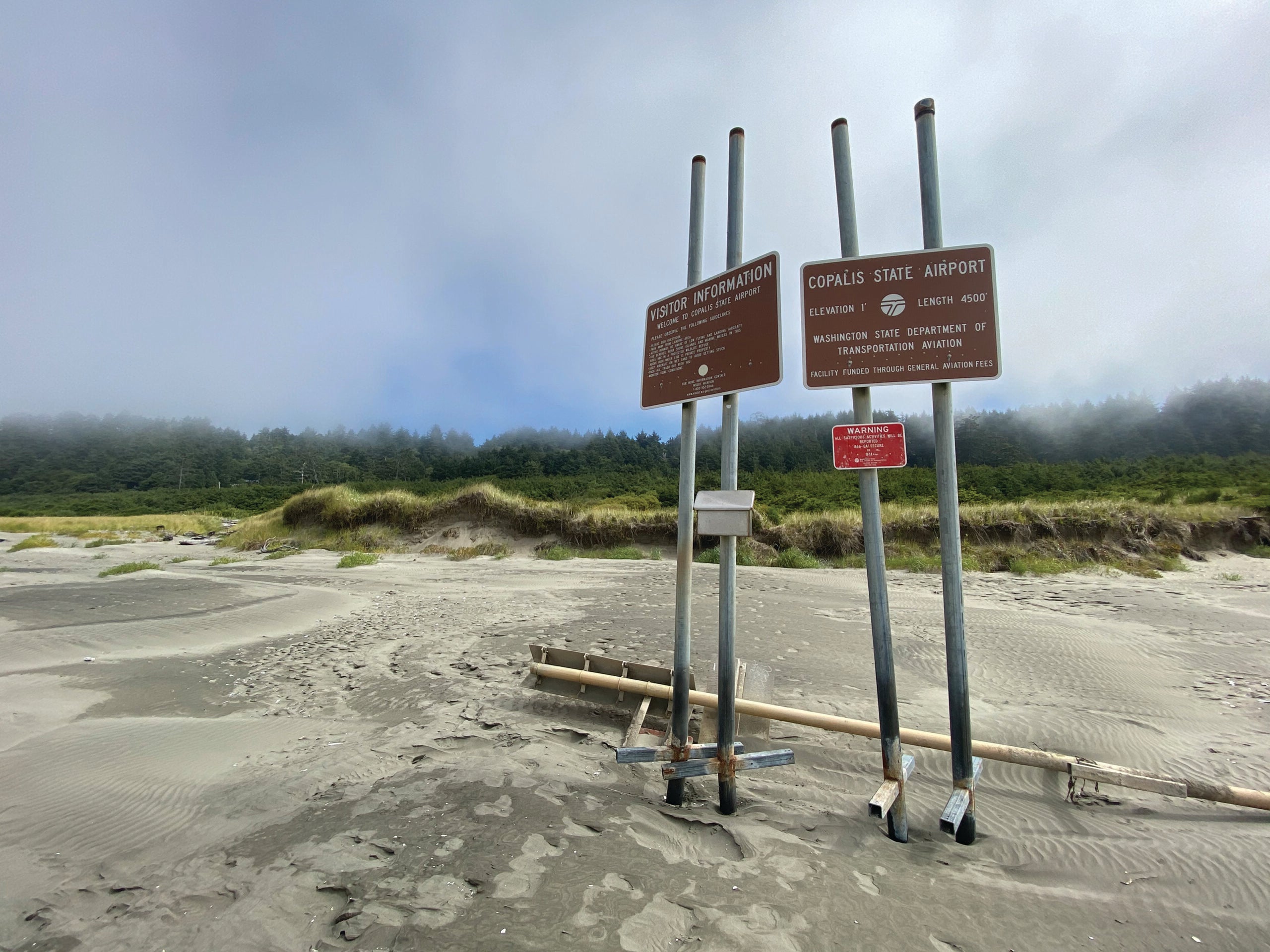
Copalis State Airport (S16) is managed by the Washington State Department of Transportation. It provides pilots with a bucket list opportunity for landing, but it is also an incredible place to visit. Since I am on a temporary assignment in Seattle and conveniently brought my plane with me, adding Copalis to my list of places to check out was a no-brainer. I’m a mountain pilot with lots of experience on unusual runways—short, tilted, rough, constrained and in general more hazardous than standard pavement—but landing on a beach brings a unique set of risks. When I asked the local mechanic for his advice, he said that he quite simply doesn’t go there due to the issue of salt. Mechanics can be such fuddy-duddy, wet blankets. So I turned to other sources to curate my risk-management profile.
Copalis State’s airstrip exists at the southern end of the Olympic Coast National Marine Sanctuary. Federal regulations prohibit disturbing wildlife in the sanctuary by operating aircraft below 2000 feet, within one nautical mile of the coast and offshore rocks and islands. This regulation does not apply to takeoff and landings from the Copalis Beach airstrip, but pilots need to be aware of it. After departing the airstrip to the North, pilots traveling flying along the shoreline must climb to 2000 feet as soon as it is safe and practicable or it is considered a violation for disturbing wildlife.
Hello Tailwheel In The Sand
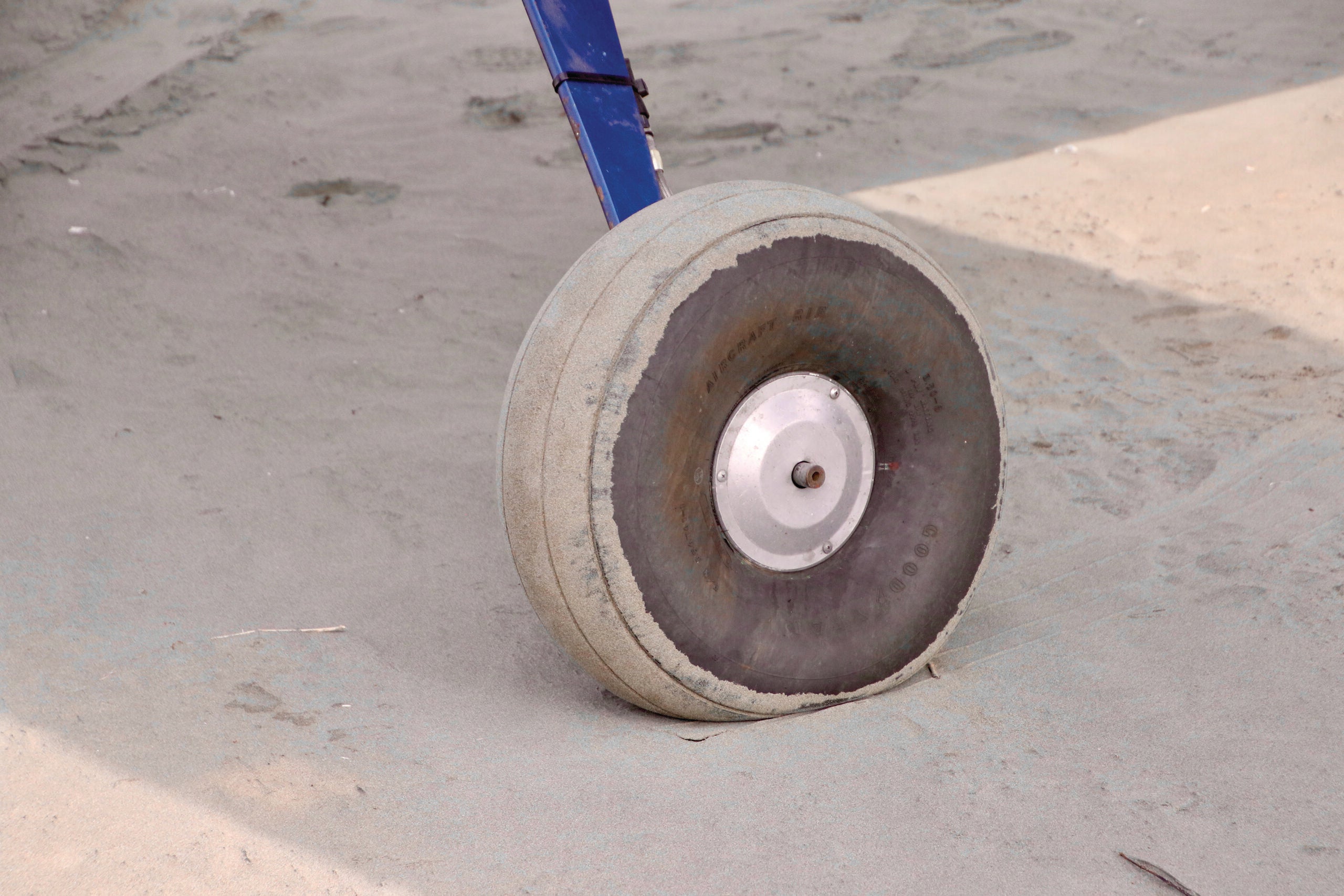
Anyone who has visited the beach knows that no matter how hard you try, some of the sand and salt is going to come home with you. The moisture your aircraft encounters will contain its fair share of salt. Neither sand nor salt are good for airframes, bearings, hinges or other mechanical systems. After a venture onto the beach, you’ll want plenty of time to detail the plane and wash away the sand and salt from every nook and cranny. Rinse off your wheels, brakes and any surface that might have come into contact with salt water.
Your Escape Plan: IFR In Class G
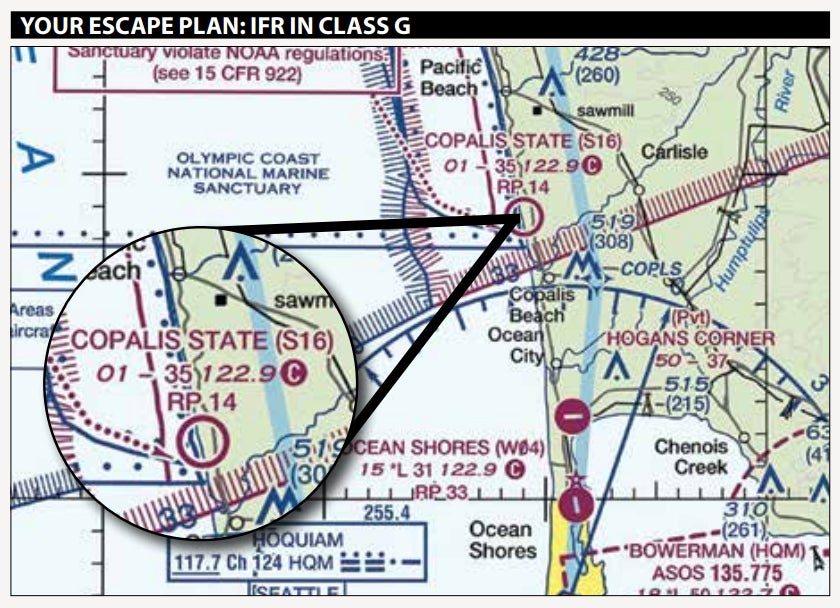
When we think of IFR, a world of clearances, controllers, detailed flight plans and reporting points comes to mind. That is generally the proper domain of IFR, but there is a little-considered world where one can fly into IMC without a clearance or flight plan: the world of Class G or uncontrolled airspace. It is rare, but there are times when exercising that option is a reasonable, acceptable and legal choice.
Imagine landing at Copalis Beach with the nearest forecast predicting clear weather. You land, park your plane and spend your morning staring at the sand and digging razor clams for dinner. After an hour focused on building your collection of bi-valves, you look up and see the sky has closed in. The weather is less than a mile visibility and you can’t see any vector where you won’t end up in a cloud. You have four more hours before the tide begins to lap against the spot in the sand where you touched down.
If you are an instrument-rated pilot, meet the currency requirements and have an IFR-capable aircraft, you are not necessarily doomed to sacrifice your plane to Poseidon. You can depart into IMC without a clearance or flight plan as long as you remain in Class G airspace. At Copalis, if you break out before 1200 feet where Class E typically begins, you are within your rights. Otherwise, you’ll need to have filed for and received an IFR clearance—probably with a void time—before entering Class E airspace. That doesn’t make it a good practice, but neither is it a good practice to sacrifice a perfectly good airplane.
Mike Hart is an Idaho-based flight instructor, sometime charter pilot, and proud owner of a 1946 Piper J-3 Cub and a Cessna 180. He also is the Idaho liaison to the Recreational Aviation Foundation.
This article originally appeared in the October 2020 issue of Aviation Safety magazine.
For more great content like this, subscribe to Aviation Safety!

Check laws before doing.
(I’m laughing at checking tide, having seen cars stuck on beaches with tide coming in.
People don’t think ahead to that, apparently thinking sand is hard.
One time was VW Beetle, which despite its tin upper body floats. So the driver at least had a chance to push it ashore once tide came in.
Tip: learn about sand before flying onto it.)
I have landed there many times, can see cabin we stay at in overhead photo. I also have seen many stuck cars (more than airplanes), but have helped push several planes out of soft dry sand to wet sand which is much more firm – but don’t get too close to water as you mention – where water table is just under surface. Another good point that you mention – cell phone. It is not only “poor” at Copalis but non existent! Unless a carrier has installed a tower close in very recent months, I have never had service. But after all these cautions, I find it a very soft and easy landing and take off.